A lesser hike that I've had brewing on a back burner of my imagination for a few years begins near the Laurel Highlands Hiking Trailhead close to PA-31. I parked there and did a majorly long loop, maybe 10 miles with frequent stops, spending a full eight hours out on the trail. My philosophy is that a good hike makes you happy to see your car--just like a good vacation makes you happy to go home. This was definitely a good hike.

From the trailhead, follow the LHHT south as it runs a little too close to the narrow lane known as Fire Tower Road--which is the road you parked along. Where the trail tries to cross the road, I exited the LHHT and made for another parking area at the Cherry Trail--a grassy old road, now a snowmobile trail, that runs through scenic forest. As I was crossing Fire Tower Road, a creepily silent white van with the Seven Springs Resort logo nearly ran me over. It was quieter than a golf cart, and I only knew it was behind me because of the way its tires crunched on the gravel. The ski resorts are surely suffering this year...

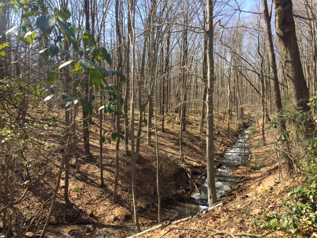
This is the Roaring Run Natural Area, a large and lovely "protected zone" of the Forbes State Forest. Camping is not permitted here, but happily neither is fracking. I visited a different quadrant of Roaring Run a few years ago--seemingly in a bad mood--and that trek is described here. Traversing really beautiful streams at the valley floor, I came eventually to the Beltz Trail, which led me in time to a Boy Scout camp known as "Conestoga-Buck Run." It was a bit of a surprise to see this old blockhouse looming through the trees near the trail's end.

This Scout camp is a huge place, but they don't seem to mind hikers passing through. From here, you follow the road into the Scout camp and eventually into Laurel Hill State Park before returning to the Forbes. If you follow the road all the way through the camp, which seems to go on forever, you come at last the the Bobcat Trail on your right. This will take you back north again to the Beltz. Sadly, I believe Scouting is in decline due to the fact that electronic devices and sports hold more appeal to most kids than trees, patriotism, and civil religion. I've never been a great fan of Scouting just because I don't like the whole ethos of "God and Country." But I think it's a better way to spend a childhood than playing video games. This place must accommodate thousands of campers.
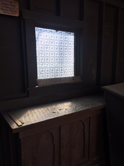
The Hagan Chapel caught my attention. (You know my fascination with religious architecture.) Even out here in the wilds, this scant little structure--just a covered chancel with outdoor seating--mimics humanity's best attempts to reach for the Sacred, or the Other. Notice the patterned glass in the window, making the sunlight that passes through it seem otherworldly. Notice, too, the Gothic design in the altar front, hinting at the great cathedrals of France and the curved arches of Moroccan palaces. Even here in the forest, you can conjure a poignant awareness of lofty things.

After following the Bobcat Trail north and back, you take a left back onto the familiar Beltz Trail. From there you turn right onto the long, long road back to your car: The Red Pine Trail. This grassy old lane runs due north along the valley wall, and it too is a very long road. In time, perhaps a very long time, you'll see the condos of the Hidden Valley Resort looming through the trees to your right. Click on this photo to see what I mean. The sight of buildings comes as both a relief and a disappointment: as a relief because you were wondering by now if you were on the wrong trail, and the presence of the resort means that you're good (there was a fork a ways back, and the trail's not blazed); as a disappointment because it means that you're not as remote as you'd flattered yourself that you were.

The road I've chosen through life is grassy lane--for the most part. It's certainly not a freeway, or an interstate, or a turnpike. I wanted a less crowded way through the world, a quieter path. And though it has led me to splendid places--to Europe, and Africa, and Asia--it has mostly allowed me to travel more slowly, to enjoy the sites, to avoid the hustle and the hassle of this world's busier thoroughfares. I should never complain that luxuries and companions are few along this way, for this was my choice. I knew that this was the spartan way when I struck off in this direction, long ago: the solitary way. And yet, a whole day in the woods made me feel almost--lonely. I was so happy to make it back to my car and, in time, to the paved-over world. Weary and sated, I haven't slept so well in months.
nice write up. roaring run natural area is actually to the west of firetower road though. everything you described is to the east, and eventually ends up in Laurel Hill State Park.
ReplyDeleteI wondered about that. On the big forest map, the stuff to the east of Fire Tower Road is not shown as part of Roaring Run, but on the little full color maps in the boxes along the trails, it looks as if it is part of Roaring Run. Thanks for the clarification, Good to know that that area is open to backpacking and overnights.
ReplyDelete