This is the impossibly wonderful Standing Stone Trail as it wends its long and sometimes painful course through the many rocks of the low mountains of Central Pennsylvania. This is the third and final segment of my sabbatical, a "vision quest" alone in the woods.
My intention was to hike all 84 miles of the Standing Stone Trail from north to south--southbound--or "SOBO" in hikerspeak. But I'm gonna tell you what I tell my kids: You can always quit. More about that below. On the morning of the first day the trail was fresh and the forest lovely. A long, steep haul to the summit of Broad Mountain reminded me that the Standing Stone is one difficult trek.

This footpath is part of the Great Eastern Trail, which is a network of footpaths that form a less crowded and more scenic alternative to the Appalachian Trail. The GET also runs from the southern end of the Appalachians to the northern end. Although Broad Mountain has the highest elevation on the SST (a mere 2,376 feet) it also has fewer good views than any other mountain on the trail. I was to learn later that it's because the other mountains--especially the aptly named Stone Mountain--are so damned stony. There are so many rocks on them that in many places trees can't even grow. It makes for painfully slow hiking, but pretty nice vistas. Here's one of the few views that opens up on the flanks of Broad Mountain.

I started off cheerfully and with great determination despite the day's 89 degrees and crazy humidity. I even pulled out my pan flute and played hymns at the first overlook I came to, just above. "Tis a Gift to be Simple" echoed like a woodland call out over the mountains where Aaron Copland's "Appalachian Spring" sets that tune to such dramatic context. That simple early American melody seemed to carry the mood of these mountains better than "Let All Mortal Flesh Keep Silence" (which was written to convey the feeling of the wistful, monotonous plains of Picardy in Northern France). The fire tower at the summit tempted me sorely because I wanted to see out over the Rothrock State Forest. But the floorboards and steps did not look safe, and I had many miles to cover.

Let me just mention here that although I played hymns on my pan flute, I am not the guy who wrote all the sickeningly overly-religious stuff in all the trail registers along the SST. I practice my faith quietly, and if you ask about it, I'll be happy to tell you about it. Otherwise I will not impose it on anyone. I certainly would never try to make it the law of the land, as some people are doing. And I won't act as if you need to see the world as I do by scribbling weird religiosity into the trail registers. But where was I? Oh, yes. Hiking trails are generally rated according to four categories in terms of difficulty: easy, moderate, difficult, and most difficult. Upon descending into Greenwood Furnace State Park, I was reminded that the 9 miles I'd just hiked were rated "most difficult." The path was very steep, rocky, and HOT!

I refilled my water bottles at the ranger station and had a chat with the ranger on duty before beginning my trudge up Stone Mountain. I passed this old Methodist church en route. It no longer has a congregation, but it's still used as a place for nondenominational Sunday morning church services for people camping at the park. It sits at the foot of Stone Mountain, which I've described elsewhere on this blog. I stopped inside the church before continuing my trek to ponder the adventure ahead and to bless the day with another song on my pan flute--of course. Great acoustics in that church for those old timey "shouting Methodists." Halfway up Stone Mountain that afternoon, I realized that I only had three liters of water, and I was going to drink it all before even getting to the top. The air felt like a sticky wet plastic bag against my skin, and I was sweating more than I ever have in my life. I mean truly, I was saturated and had to pause constantly to wipe the sweat from my eyes. There are no water sources on ridgelines, and I wouldn't come to another one for many miles. I needed to carry at least six liters of water up the mountain--that's about 14 pounds. And I needed electrolyte powder to put into the water, too. (I knew a 35-year old guy who died while hiking last summer, not for lack of water but for lack of potassium--heart failure.) So, sitting on the mountainside and pondering my options, I reached a difficult decision. I needed to get a campsite at Greenwood Furnace, hike BACK TO MY CAR and drive into State College to get more Nalgene bottles to haul water, as well as electrolyte powder.

Central Pennsylvania is truly lovely. The enormous old farmhouses and churches, the stone barns, the prim little towns with fine old trees and gingerbread trim and stately public buildings, the neatly kept farms with contour-plowed hills and low wooded mountains in the background of every scene. I saw a very stooped old woman out mowing the grass berm along the roadside where her cornfields were planted! There are farm stands selling sweet corn and squash and late summer fruits. Some of them are unpeopled and they operate on the honor system. You leave your money and take your produce. Amish buggies trot along the roadways driven by boys barely old enough to shave. But back to my tale: When I reached the ranger station it was already closed, so I couldn't get a campsite that night. I hiked back toward Broad Mountain and into the state forest (where primitive camping is legal), and there I set up a makeshift site out of view from the trail. I played my pan flute at the gathering dark, "Come, Thou Fount of Every Blessing." My intention was to hike back to the car early in the morning, then come back and reserve a car-campsite for that night, and finally to drive into State College to buy supplies. Before starting off, I explained this plan to a second park ranger, hoping she'd say something like, "Oh, honey, lemme call Roy and have him drive you back to your car," but no such luck. I had to climb Broad Mountain again, going the opposite direction, and clomp all the way back to my car, which I then drove into State College and finally re-parked at Greenwood for the duration of my SST trek. But that night in the campground at Greenwood Furnace was beautiful. Campsite #48 was perfect for a hammock tent, and though I had neighbors on all sides, they were quiet and decent--very unlike the yahoos at Shenango Lake. I drove back up to the summit of Broad Mountain, thinking to climb the old fire tower, but I lost my nerve when I saw how rotted out the boards were. I also took advantage of the summit to do some texting, since I had no reception down below. It was wonderful to get a shower that night at the campground.

Having lost a day, I reasoned with myself that time was one thing I did not lack. The third day of the thru-hike was hot and humid again but less so than the days before. "Greenwood Furnace" takes on a whole new meaning in this kind of heat. The greenwood of the northern Appalachian Mountains did feel like a furnace. The Stone Valley Vista, seen here, is two miles straight uphill from the park office, and I reached it after a long and slow trudge. See, I had been planning to hike the 84-mile trail in 10 days, covering about 8 miles a day. But I was going to carry all my food and supplies for those ten days, so my pack was heavier than it's supposed to be. A backpack is only supposed to weigh 20% of a person's bodyweight. I weigh 170, so my pack should weigh a maximum of 35 lbs. But for this trek, my pack was 48 pounds when I set off. After adding 14 lbs. of water, I slowly picked my way across the many, many rocks of steep Stone Mountain with a 62 pound pack on my back! You should only carry a 62 pound backpack if your bodyweight is 275--in which case you probably should not be climbing mountains. It sure was nice to arrive at the first beautiful overlook known as the Stone Valley Vista, a good place to rest and play the pan flute, "Of the Father's Love Begotten."

This is also the Stone Valley Vista, looking the other direction. The morning air on the mountaintop was so cool and bright, and the shaded rocks were deliciously chilly to the touch. If you click on this picture to enlarge it, you can just barely make out the brownish lake that indicates the location of Greenwood Furnace, where I'd started out that morning. The hill on the other side of the valley is Broad Mountain, though I could not locate the fire tower. Maybe it's too far to the right of this vantage point. So many things are too far to the right these days....

I had imagined that the struggle up to the top of the mountain would be rewarded with an easygoing ridge-walk where I could allow my mind to work on issues other than the pain in my feet, and legs, and shoulders. I thought that while hiking along the 9-mile summit of the mountain, I could meditate on deeper things than where to put my feet so that I don't fall onto the sharp rocks under a 62 pound burden. But I was quite mistaken. The struggle up the mountain was far easier than the ridgetop trek. The trail was badly overgrown. In places the blazes were faded or missing altogether. In other places the blazes were all that indicated the existence of a trail, for there was no established walkway, just rocks to scramble over. Worst of all, in most places the rocks were hidden under ferns and nettles and jaggers--as they used to say around here. Under these conditions, with a seriously overloaded pack, and including the time I took resting along the way, I traveled that ridgeline at a tortoise-like 1.5 MPH! Occasionally a nice overlook would appear through the trees, but it was mostly just a green tunnel with a bunch of loose, hidden rocks that shifted and moved when you entrusted your footing to them. I'm still a little surprised that I didn't fall, and I probably would have if not for my newfound habit of doing heavy hikes with two trekking poles. In fact, without the poles I'd probably be in a hospital in State College at this very moment, having been evacuated off the mountain by a rescue team.

This odd old stone structure stands at the juncture of a small side trail that ascends the mountainside very steeply, the Pole Trail--surely so named because you need trekking poles to get up it. I was tempted at this point to take the side trail down to the road that runs parallel to the ridge and walk it instead of the main SST. However, I wanted to achieve true thru-hiker status, which requires keeping a trail journal, and proving you've completed the trail by taking photos, and making a presentation of your adventure at a meeting of the trail association--where they would meet you with accolades and gifts. I was going to ask them to confer upon me a trail name, too. You know how people who thru-hike the Appalachian Trail get trail names? I thought it would be appropriate for thru-hikers on this trail to get them, too. They could name me Petrarch, after the ancient philosopher who climbed a mountain for no reason. Or they might want to call me The Vicar or The Parson. I've gone by a few different names in my lifetime, and it's fun to have alternative names... In Africa, I was Monsieur Brillant, and Monsieur le Gestionnaire, and Bise-Bise, and Le Blanc d'Elat. The thought of becoming a real thru-hiker and getting a trail name kept me going over some very, very difficult terrain with heat, and fallen trees, and no water anywhere to be found.

This is the Big Valley Vista, one of the few overlooks facing southeast. The real name of the lowland in this photo is the Kishacoquillas Valley. But nobody can pronounce that, so they just call it Big Valley, and it does look bigger than Stone Valley to the northwest.

It's many difficult miles to the so-called Little Vista, which looks toward Stone Valley again. This overlook is a place I've visited many times, always arriving from the other direction, and it was nice in a way to be back on familiar ground. It's only two miles from this vista to a public road that traverses the mountain, Allensville Mountain Road. There's also another popular overlook along the course of these two miles known as Sausser's Stone Pile, pictured below, as well as a hawk-watch deck. Families from nearby towns will often drive up the mountain, park, and walk the two miles to this overlook. For that reason, these two miles of trail are well built and maintained. Many of the stones have been gathered into cobbles, and the larger ones have been painstakingly moved to form steps, like you see in the very top photo of this post.

This is Sausser's Stone Pile. Like I said, the trail was much improved through this area, but daylight was fading and so was my strength. It was about 5:30pm when I started looking around for a place to call home for the night. I checked out the woodlands on the edge of many of these boulder fields, but then I realized another critical error in my planning: Yes, you can hang a hammock on uneven ground. All you need is trees to hang it from. This makes it more versatile in forested areas than a regular tent, which needs a clear and level spot, the kind of terrain that is rare along the SST. However, you still need topsoil to put down stakes to hold the roof in place... I couldn't find any decent place to hang my tent because there was no soil, just rocks. So I followed the trail an additional three miles or so down the mountainside toward Frew Road and the Mill Creek Natural Area, where I found some nice woods with no understory and lots of healthy dirt. A faint deer path led me off the main trail where I made a good campsite beside a convenient boulder, which I used as a table and a countertop. As darkness grew around me, I heard someone driving on the gravel road far below, parking, laughing and chatting as they set up camp, then singing into the night. Their presence annoyed me at first but then it began to comfort me. I refrained from playing the pan flute that night for fear that it might spook them. I mean really, wouldn't it be spooky to hear the doleful notes of "Rejoice, Rejoice, Believers" echoing through the woods at night--and on a pan flute?

This ugly thing is a desiccated streambed. I slept poorly, which is rare in my hammock tent. It's so comfortable, unlike any camping pad I've ever used. But I went to sleep at 9:30 and woke around 1:30 and only slept fitfully after that. As dawn drew near, I heard a strange call that I've never heard in any forest. It started off very close to me, and it sounded like a tiny horse, whinnying sadly in the dark. It had a distinctly sorrowful sound, and it had the rise-and-fall of a horse's neighing. Somehow it sounded more mammal than avian, though it may have been a bird, maybe some kind of owl that I'm unaware of. Just when I started to feel that the noise was getting too close for comfort, I heard it again much further away. [Discovered later by watching YouTube videos that the sad miniature horse in the night forest was a screech owl.] Unfortunately, due to my poor sleep, I got a much later start than I wanted. My goal for each day on the trail was to be on the move by 7:00am. It was 8:00 by the time I'd broken camp and started down into the valley, which I'd visited once before on a previous overnight trip years ago. I remembered lots of fast moving streams in the valley, and so I was in good hopes that I'd have no trouble finding water. I was wrong. I crossed two small streambeds that were dry as dust before coming upon a tiny trickle where it took me a full 15 minutes to fill and treat all six of my water bottles--the three I brought from home and the other three I'd just purchased in State College--along with a very expensive hat to replace the one I foolishly lost on my second ascent of Broad Mountain.

The water was shallow and scant, but clear and cold, and it tasted good. In that day of hiking, every stream I crossed was completely dry. It's a good thing I didn't wait for something more appealing than that first sluggish little trickle that I found; there wasn't anything for miles. Even some of the full sized creeks that I'd crossed on my previous trip into the area were entirely empty.

Some miles later, I did find just one little brook that seemed not to be aware that there was a severe drought afflicting Pennsylvania and New York--and indeed much of the world. This little stream just bubbled and gurgled happily, calling out like an angel of the forest. I sat on its banks and drank two of my bottles of previously-treated water, then I refilled them again. But...it was heavy! That water was just so accursedly heavy. If the streams had been running, I wouldn't have needed to stock up. This is the grim paradox of hiking in an August drought: the more water you carry, the more you perspire, and the more water you need! Ah, but it is a joy to hear gurgling water in a dry and weary place.

This is State Game Land # 112, where camping is not allowed. I was required that day to hike some 9 miles through the gamelands and three miles steeply up to the ridge of Jacks Mountain before I could put down camp for the night, just inside the border of state forest lands. I didn't see how it was going to happen. I still hadn't entirely recovered from the previous day's rough-going, and my 62-pound pack was really beginning to weigh on me. Maybe I'd have to stealth-camp on the gamelands? But that would eliminate me from earning thru-hiker status from the trail association; their website says so. And I wasn't willing to lie to them about where I'd camped. At one point as I was rushing through this beautiful forest, which I should have been observing and enjoying, I found myself thinking something that I'd thought many times the previous day: "Why do I do this? This isn't fun, it's awful." The mosquitoes were eating me alive. I'd lost my mosquito net somewhere on Broad Mountain--which thing I loved and called my Minister's Black Veil, after the short story by Hawthorne. (Turns out I hadn't lost it at all; it was just tucked into a place in my pack where I never remember putting it.) My pack felt like a dead man on my back. I was making terrible time. I'd caught about two dozen spiderwebs in my face, despite using one of my trekking poles as a prow and walking through the forest like a fencer en guard. Most places where I backpack, I only carry two one-liter water bottles. When one of them is empty, I fill it. But here, even without a drought, water sources are rare because most of the trail follows ridgelines. During a drought, you have to carry so much water that your pack is unbearably cumbersome, and then the few water sources that exist might be dry. It was a joy to come across this little patch of blackberries. As I paused to pluck and eat them, I remembered the trick of cupping your hand beneath a cluster of berries so that the other ripe ones don't fall to the ground when you grab just one of them. It occurred to me in that moment that I've never taken my daughters berry-picking, and they probably wouldn't know a blackberry from a poisonous pokeberry. So much is being lost. I felt a deep sadness at that thought. I mean truly deep. I almost wanted to weep, but didn't because I just don't.

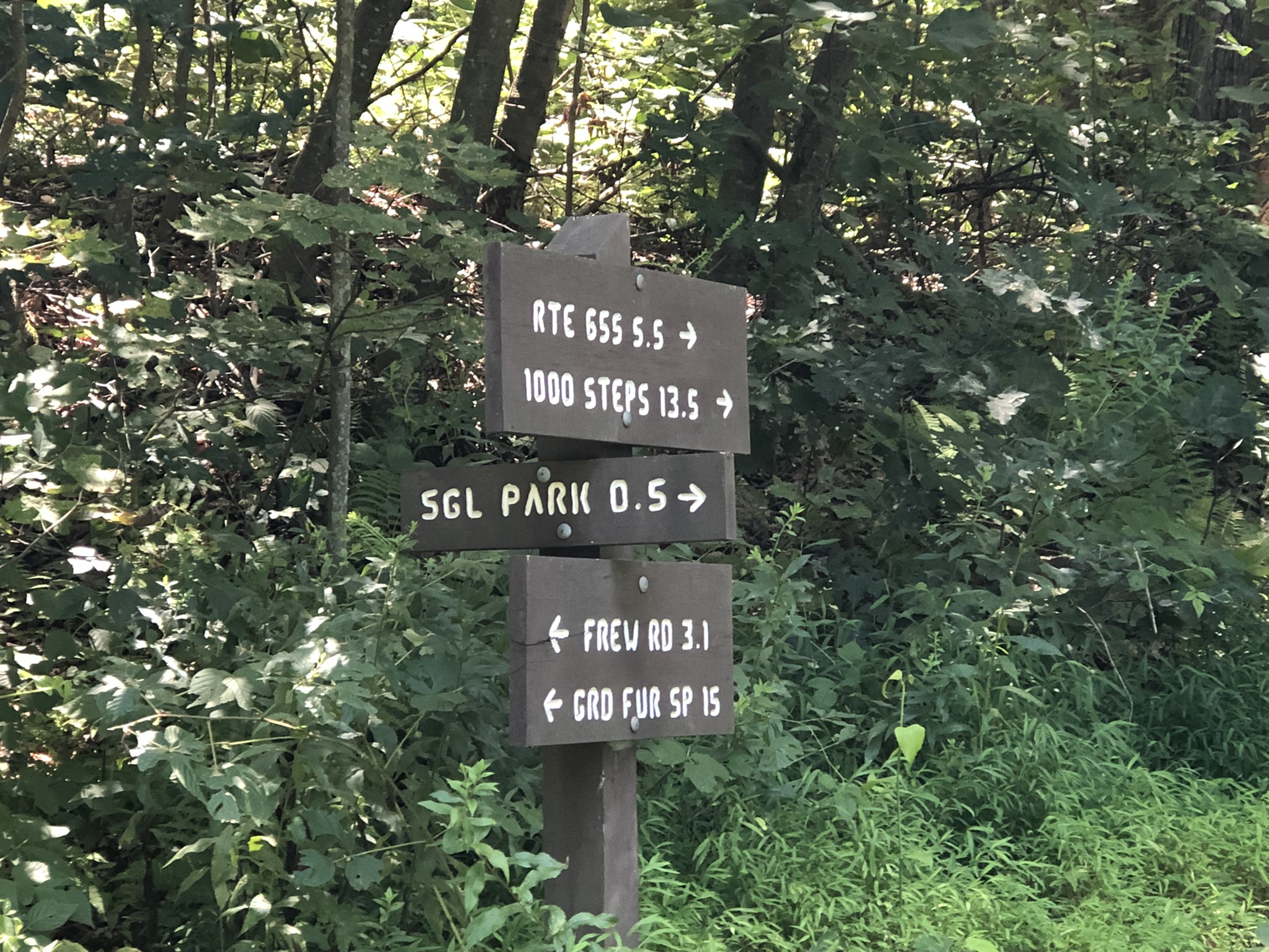
As I pondered my poor time--about 1.9 MPH--and how difficult it was going to be to climb Jacks Mountain after this hustle through SGL 112, the trail took a turn and followed a pleasant forest road, which I saw on my maps. I paused under this sign to spread Babybel cheese on a hard bread that I thought of as a johnnycake. (Johnnycakes were originally called "journey cakes," and they were a hard bread that wouldn't mold on the trail.) "Hmm," I thought to myself, "there's a public road just half a mile away. Maybe I could go out to the road and hitchhike the 5.5 remaining miles to Jacks Mountain? Surely my wasted day crossing Broad Mountain on foot for the second time makes up for a little cheating at this point? I mean, that was 9 extra miles, so it should more than atone for my missing out on these 5.5 miles, right? It's not unethical, is it?" I gave in to temptation. I went to what I thought would be a little gravel forest lane like the one I'd been walking on. But Mill Creek Road was broad and paved, and the pavement was HOT beneath the summer sun. For the first time in many years, I tried to hitchhike. I thumbed the first and only car that came past. I took off my hat and smiled, trying to look respectable, or at least not-scary. They zipped past without a backward glance. In time, just as I was beginning to despair, I walked past a cabin where a gruff-looking bearded fellow called out, "Hello! How are you?" Switching into the Pennsylvania countryspeak that I recall from my childhood, I said in all honesty, "I been better. How're you?" He said, "We don't get many hikers here." His name was Greg, and though it was 2:00pm, he was just firing up the grill to make lunch. He put everything on hold and offered to drive me back to my car at Greenwood Furnace. Up to that point I was still entertaining the notion of catching a ride to the foot of Jacks Mountain and continuing my trudge. Greg probably would have taken me there. But something snapped. I gratefully accepted...and then tried to avoid talking politics for the 20 minutes that it took to get back to Greenwood Furnace. (I noticed that his Sirius Radio was tuned in to Fox News.) He said, "Don't feel bad, man. Look at that mountain you just walked," pointing up to Stone Mountain, which loomed above us like a sinister math teacher. "You walked 30 miles over rough terrain, with how many pounds on your back? I couldn't do that!" His words did help, actually. Then at the park office, I had to go in and admit defeat to the rangers who were keeping watch over my car and reporting to the rangers at Rothrock and Cowans Gap that a thru-hiker was on the trail. (What with all the emails that circulated among the rangers about me parking and doing the whole trail, I can never show my face in that place again.) Honestly, if not for the drought, I'm very sure I could have finished the 84 miles. But with a 62-pound pack, it just wasn't possible. My muscular dystrophy has been advancing so rapidly these past three years. I really wanted to be a "thru-hiker" and to get a trail name. But at least I got to add Broad Mountain to my peak-bagging page--even if it is a meager 2,376 feet. I think maybe I should stick to the kind of trek I'd been doing, where I hike deep into the forest, set up a base camp, and do unencumbered day hikes all around it--with no backpack, just a water bottle. In fact, I'm leaving tomorrow morning to do just that at Roaring Plains. And I'm taking the pan flute. It was really fun to make music in the woods.