Sunday, March 31, 2024

Point Hill, Franklin, PA


Despite some hardscrabble neighborhoods, Franklin is a quaintly scenic little town.  It’s got a busy Main Street with no empty storefronts and more than just the usual Subway and Dollar General.  There’s a decent independent coffee shop, a few good restaurants, a few tobacco shops, and a curious museum of musical instruments.  There’s a nice downtown park and ornate street lamps, too.  It resembles Bedford Falls from “It’s a Wonderful Life.”  Franklin is the seat of the once opulently rich Venango County, so the public buildings are impressive.  Here’s the county courthouse with the jail behind it, wearing a red tile roof.  But the thing that interests me more than the town itself is the hill that you see in the background.  


That’s the sensibly-named Point Hill, which stands some 500 feet above the town.  French Creek and the Allegheny River converge in the valley at the mountain’s foot.  A Scotsman had a trading post here as early as 1740, and by 1753 the French had built Fort Machault near the confluence of the two bodies of water.  That’s when a 21-year-old George Washington arrived in Franklin unsuccessfully trying to warn the French out of the Allegheny River valley, which was claimed by Virginia and the British Crown.


It’s hard to believe that two of the world’s greatest empires were willing to fight over this place.  It’s a pleasant hike up to the summit of Point Hill, and there are a few modest views.  We were having an Easter get-together at my in-laws’ house, but my daughters and I had a few spare moments to bag a humble peak while the others were lying around the house, gossiping about people we don’t know. An unfriendly pit bull accosted us on the upward climb.


So many towns in this region have a low, wooded mountain or two in the background.  It’s fun to climb them and see what’s up there, see the whole place from an alternative perspective.  I’ve been passing though Franklin all my life, and I’ve finally explored the hill that stands as the backdrop to scenes I know all too well.  Funny how long it takes for some things to happen.  Point Hill is only 1,420 feet, but as I keep telling this blog, anything over 1,000 feet is considered a mountain. 2nd Avenue becomes a narrow gravel lane, which runs all the way to the towers up top. There seems to be a network of trails up there, too, but perhaps another day. 


Saturday, March 23, 2024

Baker Rocks, Garland, Pennsylvania


I thought Baker Rocks would be a quick and easy peak-bag.  It seemed like a clear path on my maps, and though there was almost nothing about the place online, how can you miss big rocks?  I went out Friday in the late afternoon, thinking I would find them with no problem.  I left the car at the parking area in State Game Land 143 at about 5:15 pm.  I followed what I supposed to be the trail—straight up the side of the mountain, but daylight was fading, and I had to call off the search.


The rocks are advertised on this sign as you enter the game lands, so they must be worth seeing, right?  


Then again on Saturday afternoon I set off to find Baker Rocks, ascending the mountainside from a different route.  This time I bushwhacked up a very steep face that looks east.  This was a real climb, grabbing from tree to tree to keep from slipping backward and downhill.  But it’s a good thing there was a bit of snow on the mountain, for on the return trip, I had to follow my own footsteps back down to the car.  This was a much more pleasant day in the woods, but still no Baker Rocks.


There’s supposed to be a broad vista out over the valley below as well as some caves and boulder fields.  I’ll have to come back.  I’m pretty sure I know where I went wrong the last two times. 

Fools Knob, Allegheny National Forest


Fools Knob shows up on all the maps, so I assumed there’d be something to it.  You know, a “knob,” a rocky outcropping, a visible brow of a hill, a clear, sharp ridge line…  There was none of the above.  Just another partially clear-cut upland with felled trees obstructing the path.  I had never visited this quadrant of the Allegheny National Forest before.


The woods felt spooky to me that day.  It was strangely dark, and an old man I met walking the forest roads spoke of unmarked graves beneath the hemlocks—women who farmed this land after their husbands died and who were imagined to be witches because they lived out in the forest with no one to protect them.  There are little pockets of private land within the bounds of the national forest, some of which still have old houses or cabins on them.


Fools Knob has a curious name…a name that called to me, honestly.  At 1,670 feet above sea level, it’s exactly as tall as the high point for the state of Iowa, which is in a cornfield, I think.  I might come back to this part of the forest someday to find those graves.


Monday, March 18, 2024

Fort Necessity National Battlefield


Sunday afternoon, with the family all gone away their different directions, I decided to bag one more peak before my Secret Peak-Bagging Nemesis got to it.  (Anonymous carpetbagger from New York State who comes down here to claim all the easy peaks without even honoring them with a quick description or a single photo!)  It had to be a mountain near Pittsburgh because I only had a few hours to complete the task.  So I trained my eagle-eye on one Hager Hill, which is inside the Fort Necessity National Battlefield.  Here’s a shot of the reconstructed fort, which a young George Washington hastily improvised in 1754 in a place called Grassy Meadow.


And here’s the viewless vista from the summit of Necessity Hill, which stands at a respectable 2,120 feet.  Necessity Hill is the ridge just above the fort, and it’s the peak I ended up bagging, but it’s not Hager Hill.  Also, two other members of my peak-bagging club had already been there, so I did not get to claim “First Ascent.”  I will not tell you whether one of them was indeed my Secret Peak-Bagging Nemesis.  


I brought my daughters here many years ago, when they were little.  I tried to inspire a sort of “pride of place” in them.  I showed them Jumonville Glenn, where Washington plunged the American colonies into the Seven Years’ War, which we call “The French and Indian War,” probably my favorite of all the wars—if I’m allowed to have favorites.  I showed them Braddock’s grave, where he was buried under the road after dying from his wounds while trying to take the Forks of the Ohio (Pittsburgh) from the French.  I showed them the isolated grave of one Tom Fawcett, a scoundrel and hermit who had been one of Braddock’s soldiers and who claimed that he shot Braddock in the back for being such a prick.  In this photo you see a bit of the road that Braddock hacked into the American interior.  


And of course, I showed them Fort Necessity, seen here.  I also took them downtown to the Point to see the outlines of Fort Duquesne and Fort Pitt.  I never showed them Bushy Run, or Ligonier, or Hanna’s Town, though (God help them) they are half Hanna.  When they were little, they found it all very interesting.  Now?  Well, things are different now.  They would never want to accompany me on ventures like this…


And though I managed to be the third person in my peak-bagging club to nab Necessity Hill, I did not end up bagging the yet-unclaimed Hager Hill, my original goal.  There’s no trail to it, and I did not have enough daylight to do a proper bushwhack.  Even to get to the top of Necessity Hill, you’ve got to take the trails up as high as they’ll go, then ignore the sign telling you that the lane to the top is for “Authorized Personnel Only.”  (I think it’s referring to vehicles, not foot traffic.)  There’s nothing up there but more trees, as I pointed out in the second photo above.  Maybe I’ll go back for Hager Hill someday, but it didn’t honestly look all that interesting.  Sometimes there’s a reason a peak goes unclaimed.

Saturday, March 16, 2024

Babylon Hill, Near Tidioute


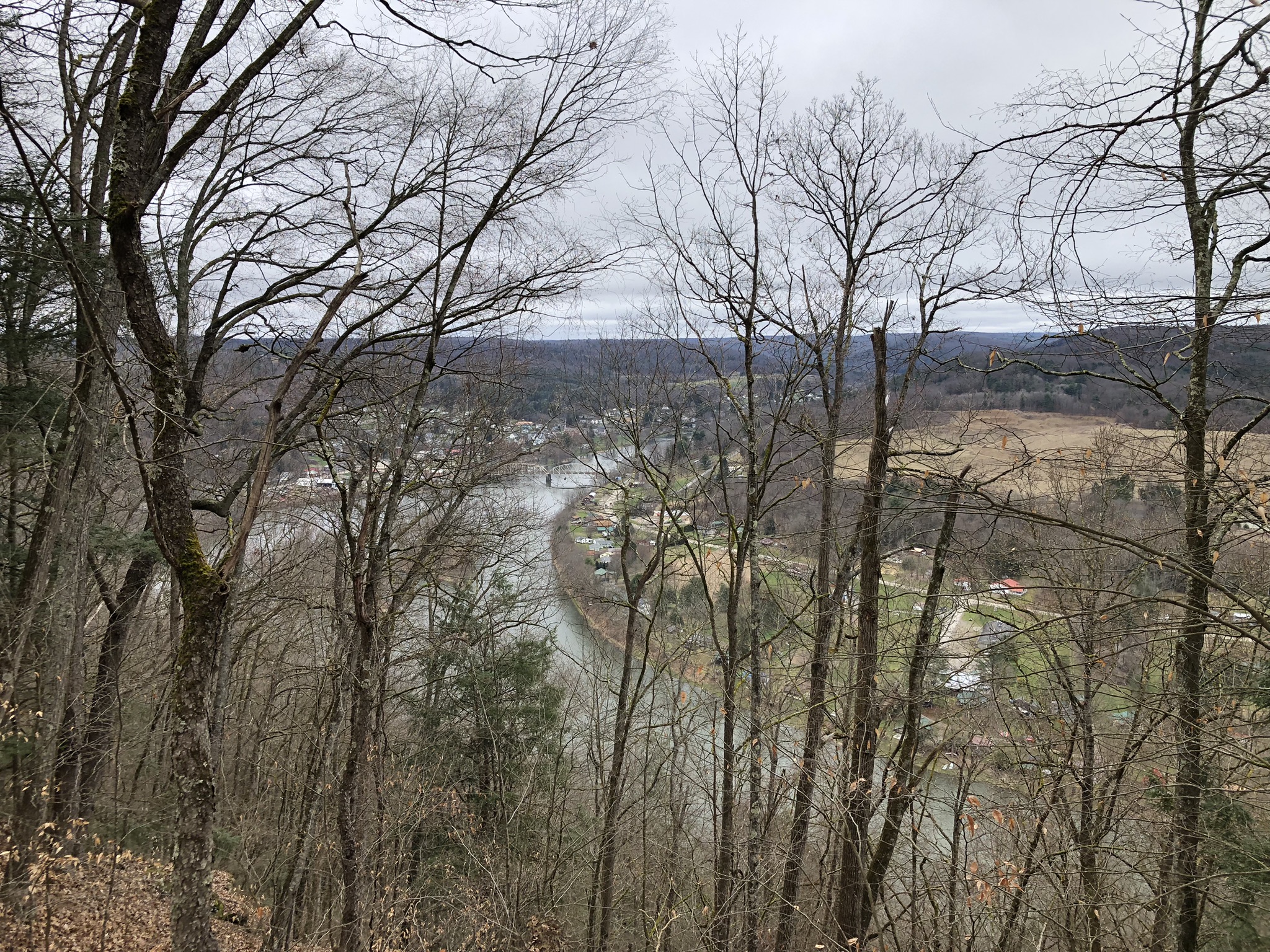
This is the view of Tidioute and the Allegheny River from the top of Babylon Hill, which was an unclaimed peak in my peak-bagging club until yesterday.  It’s only 1,624 feet above sea level, and 510 feet above the river, but it’s MINE!  Babylon Hill is all mine…


Views are rare up at the summit, and they’ll be even rarer by mid-April, though old electric line easements provide an occasional break in the trees.  But let’s talk about Babylon Hill’s wonderful name.  My father and his family are from this area, and he used to talk about a notorious figure called “French Kate,” a professional criminal ad former dancer who ran gambling dens, and brothels, and bars and very disorderly houses in the old ghost town of Pithole—which, back in the days of the world’s first oil boom, here in these hills—was as wild a place as any California gold town.


French Kate was best known as a madame.  She provided female companionship for the oil workers who flocked to Northwest Pennsylvania from all over the nation, and the world, to make their fortunes in the new oil fields.  She was a garish woman who painted her face, wore expensive jewelry, and always had the latest styles from the coast.  It’s said that she was educated and a polyglot.  She carried a pistol in her bra and wasn’t afraid to use it.  My father used to say that she and the pimp across the street in the boomtown of Pithole used to shoot at each other from their windows.  “The pimp across the street” was the infamous Ben Hogan, another erstwhile legend in these parts who ended up becoming Kate’s lover and then converting to Christianity and returning here to preach salvation from sin.


But I digress.  After Kate and Ben fell in love, and before Ben got religion and became an evangelist, they began to run afoul of the law in back Pithole.  They decided to join efforts and open a new brothel and dance hall together on top of the mountain just outside Tidioute, a wealthy city on the banks of the Allegheny.  Babylon Hill is steep, but only 510 feet above town, so French Kate knew that the uphill trek would be a deterrent for the police, but not for her more highly motivated clientele—lonely oilfield workers from Ireland and Brooklyn.  Those guys lived in the oilfield barracks and rarely saw women, so they’d have climbed Everest for what Kate had to offer.


So she and Ben Hogan put their new brothel at the top of Babylon Hill—so named because the respectable townspeople knew it as a place of vilest debauchery, and Kate herself was “The Whore of Babylon,” with her fancy clothes, and her urbane ways, and her band of dancing girls for rent.  The name stuck, even though there is nothing to be found up on the ridge today but pleasant forests of white pine and hemlock.  See the mountain’s name near the middle of this map?  And see how sharply the land descends toward the river?  It’s technically within the bounds of the Allegheny National Forest, so it’s possible to camp out up there…with all the ghosts of the prostitutes and immigrant oilfield workers who came to untimely ends up on that peak.


To think that this was once a place where impoverished young women were viciously exploited and abused, where there were 20 men to each lady, which often led to fistfights and knife fights, a place of licentiousness where Kate herself shot and killed two of her own clients.  I don’t say this to be judgmental; it stands in such contrast to the quiet, peaceful place it is today.  I need to do more research.  I believe that the shooting ended up getting the business closed down after just 9 months in operation.  Ben and Kate then turned to running gambling barges up and down the Allegheny River until Ben “got saved” and Kate left him.  I don’t know what ever happened to her.


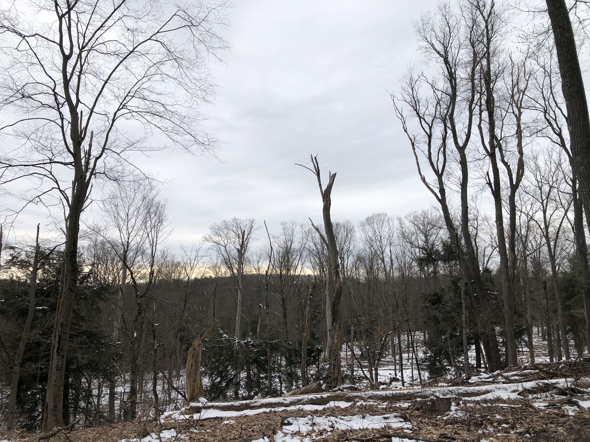
This is the summit of Babylon Hill.  You can hear the bustle of the little town below and the distant hum of US-62, the small highway across the river.  You would never guess its history, but such is the way of these dark Northern forests.  This land was once denuded of all trees, covered in oil derricks, and crawling with luck-seekers from all the world over, some of whom were overnight millionaires, but many of whom just went from misery to misery.


And here’s an old postcard of the view from up high.  Before doing this trek, I read a very long and entertaining article from 1932 about Pithole, Babylon Hill, French Kate and Ben Hogan, which made it all the more fun.


And here’s the old forest lane, looking downhill, that travels up to the ridge line from the rail trail at the river below.  It’s quite steep in places.  Park at the Tidioute Rec & Trek Trail, follow the river for 1.5 miles, to the place where Grove Run comes tumbling down the mountainside from the right.  There’s a small waterfall, and this steep lane cuts sharply uphill to the right of it, as seen in the fourth photo from the top.  The whole out-and-back is only about 4.5 miles, though I explored the mountain and ended up doing a road-walk back to my car.  Also on this trip I bagged a peak called Preacher Hill, of similar height, but it was a dull and gloomy place, which could be how it got its name…

Tuesday, March 12, 2024

Tidioute & Environs


On the day I explored Davy Hill, I passed slowly through the quaint little riverside borough of Tidioute and said to myself, "I need to spend some time here."  Little did I know that I would get my wish.  Tidioute is one of those classic little river towns on the northern stretches of the Allegheny where you can find grand old mansions like this with their terrace-gardens running all the way down to the water's edge.  I didn't get many good photos of Tidioute because my visits there were less than ideal for that kind of thing. 


What? More Presbyterians? Tidioute is like so many villages in this area: a curious mix of scenic and stark, sumptuous and squalid.  Any such town with a lovely rural setting like this in Vermont or New York would be all antique stores, and bike lanes, and brew pubs.  Not so, Tidioute.  The one dusty antique store in Tidioute looked like its doors hadn't opened in years.  A lonely interior decorating shop stands in ambitious splendor---either a sign of renewal or blind optimism.  Once-opulent old homes and buildings line Main Street in varying stages of upkeep and decay.  A lovely north country setting presides over all, in the form of forested hills and shallow river.  Most of these faded river towns have a single grand bridge to traverse the river that gives them their identity and charm.  


I've told this blog before: According to my long-dead grandfather, Tidioute got its name from a Seneca woman who went around topless.  Who knows?  Another advantage that Tidioute has is its rail trail, which is a dead end trail following a former railroad bed along the west bank of the river for about 10 miles before dead-ending.  This pleasant Airbnb stands on a hill at the edge of town, overlooking the river and the trail.  I stopped to hike a few miles on the rail trail and to plan my glorious ascent of the extremely steep Babylon Hill, which is in the Allegheny National Forest just south and west of town.


It's a beautiful walk, if a little muddy.  In places, the islands in the river block the ugly little camper and trailer settlements on the opposite bank.


In some places the trail is graveled.  But most stretches are just wet earth.  Not sure you'd want to bring a bike down here.


Map-work brought me to this spot where Grove Run flows off Babylon Hill and into the Allegheny River.  The unmarked and unmapped trail up the hillside in this photo goes to (or near) the summit of Babylon Hill--I believe.  That's my next virgin peak to bag.  But I didn't have the time or the gear to do it that day--a long, steep ascent on wet leaves requires poles or at least a walking stick.  So I headed back to the car with my plan for next time.  Arriving back at the car, the day got weird.  It was raining hard.  My key got stuck in the door, trying to unlock it.  I mean, it was really stuck.  AAA was of no use at all in this area.  My first frustration with them came when I had to tell an automated voice that I was in "Tidioute."  That was less fun than it sounds.  They decided I needed a locksmith, not a mechanic, and called me back half an hour later to say that there is no locksmith responding to their appeals.  Then I called one of those 24-hour locksmith companies with the same result.  During all of these long, frustrating phone calls, while talking to automated voices on the phone, my phone battery was draining and it was raining.  I finally had to walk half a mile into town, try a few businesses until I found a hardware store, where I bought WD-40, which didn't work, and borrowed a pair of needle-nose pliers.  Nothing worked.  When at last I did manage to wriggle the key out of the lock, I still wasn't able to get back into the car.  The hardware store, half a mile away, was closing at 4:00, and it was 3:30.  I rushed over to return the pliers, and they directed me to a mechanic who opens his shop at 4:00pm.  Nice guy with double ear-piercings from North Carolina.  He popped my car open, and I was able to drive home with a damaged car key.  The whole fiasco lasted from 2:00pm to 4:00.


The countryside around Tidioute is worth exploring.  Follow Campbell Hill Road as it wends a little scarily up away from town, and you come into a broad area of dense woods and old farms that are now mainly hunting camps.  


I wonder what it does to housing costs in this area when suburbanites come in and buy up all the affordable properties and turn them into camps.  My conscience still bothers me about that--despite the fact that a real estate agent assured me that when the seller demands a cash-only sale, it's more the fault of the seller than the buyer.  Anyone who really needs to buy affordable housing can't swing a cash sale, in most cases.  Our whole system is just so broken...  This beautiful old farm probably sees only about two or three weeks' occupancy a year, I'd guess.


This old farmhouse looks like it was a hunting camp for a long time, but now someone is rehabbing it for a year-round home.  I suppose the swing can go both ways.


There was a really cool camp sitting in pristine isolation up here on Campbell Hill Road, just above Tidioute, selling for $90,000.  (Not the place pictured here.)  But the road is very muddy and even slick.  I think you'd need a better vehicle than the one I drive.


Maybe this was an old schoolhouse at one time?  Now it's hunting camp.  It's such a joy to explore these wild lands on foot or by car.

Monday, March 11, 2024

Neiltown Church, Forest County, PA


This is the old Neiltown Church--or Neilltown, which seems to be the preferred local spelling.  It was built in 1843 by the Neill family, who were local property-owners.  The little hamlet of Neiltown (or Neilltown) consists of about 10 or 12 houses just inside the western boundary of Forest County.  It hasn't had a regular congregation in many years.


Religious services were held in the area as early as the 1790s, but the Neiltown congregation got its official start in 1822 as Concord Presbyterian Church.  About 100 years later, the church sank into decline.  I'm not sure when it closed up shop, but I do know that it was just an empty building by 1970.  These photos were all taken by pressing my iPhone 8 up against the windows from the outside.  


Here's the narthex which--like far too many narthexes in this world--doubles as a storage closet!  And how do I know that the congregation had disbanded by 1970?  Well, it's like this: About 20 years ago, I was ordained by the local "Lake Erie Presbytery," which encompasses this area--and which is like a diocese.  When I was ordained, I was given a book about all of that denomination's congregations in this area, with histories and photos of their buildings.  The book was dated 1970, and the Neiltown Church was not in it.  Which is to say that the congregation had gone out of existence before that year.


It's got a simple, elegant interior.  I believe that's probably a piano under the white sheet in the foreground.  In 2004, the Oil Region Alliance bought the building in order to preserve it, and it's now a venue for summer concerts and memorial services.  They tried to have two or three interdenominational services a year inside the church, but that no longer happens. The church has a Facebook page with 105 followers--including yours truly.  The page hasn't been updated in a year or two, but it does indeed show photos of musical concerts inside the building.


There are so many beautiful and historic rural churches up here, and many of them Presbyterian.  Neiltown is one of the least interesting, frankly.  But it is a unique and peaceful place, surrounded by a cemetery.


You can also rent the church for events. 

Davy Hill, Near Tidioute, PA

There's no good reason to climb Davy Hill, which is technically a mountain.  The wooded summit looms darkly above the valley of the Allegheny River in its wild far northern reaches in Warren County, very near to our hunting camp.  
At 1,578 feet, Davy Hill does not meet my 2,000-foot minimum height standard for peak-bagging.  But the heights just aren't as great up here, even if everything else is better.  It's very odd; as soon as you cross over into New York State, suddenly there are a lot of peaks that exceed 2,000 feet.  But on the Pennsylvania side, most don't get much higher than about 1,500 to 1,800.  So...I guess I'm gonna have to cheapen my already cheap self and lower my standards.  (Nothing new.)  1,500 feet is now my new minimum for mountain climbing.
I only wanted to climb Davy Hill because no one in my peak-bagging club had ever done it before.  It stood tempting and unconquered on the west bank of the mighty Allegheny.  So now it's mine, humble as it is.  Also, the mountain itself is on public land, State Game Land 86, as is almost the entire climb.  You have to follow a power line swath up from the tiny riverside hamlet of Cobham, which is mostly second homes for hunters, fishers, and those happy souls like me who love the river and the forest.  It's actually quite a steep ascent in places.
Going east and north out of Tidioute, there's a narrow lane that runs scenically along the river.  The properties right on the river are everything from palatial to squalid.  After a few miles, the riverside lane turns to mud, and the paved road goes left up the side of Davy Hill.  In order to make it a fair ascent, you've got to begin here at the bottom, though it's possible to drive all the way to the top.   (Driving to the top does not constitute bagging a peak.)  It's not a long trek up to the summit, with an elevation gain of only about 500 feet.  The ridge is scenic, albeit without long vistas.  As consolation, there are traces of a long-ago farm.  
Beautiful white pines dominate the mountaintop, the kind that are so widespread up here in the north country.  And as evidence of the long-gone farm, there are grassy old meadows, rows of evergreens, which were planted to create wind-barriers for barns or a farmhouse, and even a tattered old apple orchard where a few shaggy apple trees still stand.
These are all public lands now, open to exploration and hunting.
Personally, I've never been hungry enough to point a gun at an animal, but life is long.  Old, unmarked trails crisscross this countryside.  An old farm road leads to the ridgetop parking lot, which is accessed from Davy Hill Road, which is the cheater's way to get to the top.  It would be fun to come back and explore this place further, but there are just so many places to explore up here.  It's glorious to be back here after all these years.