Friday, March 17, 2023

Helldiver Crash Site in the Laurel Highlands, My New Obsession


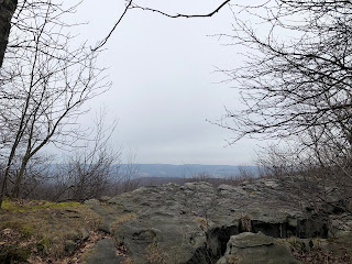
I mean…you know by now that I’m obsessive, right?  I get going on a topic, it occupies most of my energies for 4 or 6 months, then I’m on to something else.  I am going to find that damn Helldiver crash site on Sugar Camp Hill if it’s the last thing I do.  Which thing it might well be.  Here’s the Laurel Highlands Trail as it passes between the tall rocks between miles 57 and 56–or maybe 56 and 55.  


And here is the Navy radioman, George Cohlmia, whose body was found 50 feet from the smoldering Helldiver fighter jet.  He was one of 10 children of Lebanese immigrants to Oklahoma (of all the world’s many places…)  In George’s obituary, his father is called “Rev. Cohlmia.”  Must have been Baptists fleeing religious oppression in the homeland: out of the frying pan into the fire, quite literally.  He was a high school athlete who voluntarily enlisted as soon as he turned 18 and then died at 19.  


It weirds me out because my oldest child is 18, and in my mind still a sweet toddler asking me to read to her.

Sadly, there’s almost nothing online about the 23-year old Frank Z. Campbell who was flying the plane.  It seems that he had no siblings, so there was no one left to remember him after his poor long-widowed mother died in 1983.
 

Thursday, March 16, 2023

2nd Futile Search for 1945 Helldiver Crash Site


This is Rager Mountain on the east side of the Conemaugh River gorge.  The river—which was responsible for the infamous Johnstown Flood—is unseen in the valley between the mountain and me.  Much of the woodland on this mountain belongs to the Gallitzin State Forest, the Charles F. Lewis Natural Area.  Alas, I experienced a regret up there in those woods on a July day many years ago.  Notice that it’s early spring here in the river valley.  


But you don’t have to hike very far up onto the mountainsides to find snow and cooler temperatures.  Yes, this photo shows a nuclear power plant at the end of an ugly electric line easement.  I mean, c’mon, there’s pretty stuff here and there, but it’s still Pennsylvania we’re talking about…. My goal today was to return to the area where I explored last week (see the post just below this one) and to ride an old bike 6 miles down an old dirt lane in order to find the Helldiver crash site from 1945.  What I didn’t count on was all the ice and snow on the mountaintops.  There was no way I’d be riding a bike up there.


So I went instead to the very beginning (or end) of the Laurel Highlands Hiking Trail, near the village of Seward, and hiked uphill from mile 70 to a spot beyond mile 68.  It was a nice trek on a sunny day in early spring.  The air was fresh and bracing.  


This iron bar sticks out of a boulder along the trail. Who knows why?  The remains of old roads up and down the mountainside reveal the place’s industrial past.  This ugly piece of metal is just ol’ Mother Pennsylvania reminding you about her sordid past.  “Don’t forget,” she whispers, “never forget that I was once the smoking hearth of this world.  I reserve the right to be ugly and horrible when you least expect it.”  


The only real views were from the second electric line easement.  This is the Conemaugh River gorge.  A sign near the river, down below, claims that it’s the deepest gorge east of the Mississippi, but I sure think the New River gorge in West Virginia is deeper.


I have to admit that I set out this morning with a sense of foreboding about trying to find the crash site again.  I almost felt relieved when I thought maybe the bike wouldn’t fit in my car—but it did—or that I couldn’t find the pump to put air in the bike tires—but I did.  Then by the time I got to that faraway mountaintop and saw too much snow for bike riding, I was not relieved but disappointed.  So, yeah, I didn’t accomplish what I set out to do today.  But this was nice too.  Third time’s a charm, right?


Friday, March 10, 2023

Futile Search for 1945 Helldiver Crash Site

NOTE TO READER: The post below is old.  I did finally find the crash site!  To read that article, along with directions for finding the site, go HERE.
It was the longest hike I've taken in a while.  12.4 miles out-and-back on a remote section of the Laurel Highlands Hiking Trail--which is to say 6.2 miles each way.  Averaging about 2.2 miles an hour, I got it done between 10:30am and 4:30pm.  But in that time, I did take a few breaks.  Six hours with very little weight on my back.  It might be another story when I come back to do a thru-hike in July, when I've got one 13-mile day planned and one 14-mile day.
One really nice thing about the Laurel Highlands Trail is that there are markers every mile, so it's easy to gauge your progress and to say where something is located.  "Oh, yeah, there's a stream between such mile and such mile."  On Facebook I read recently that between mile markers 51 and 52 there's an unmarked path that leads 1.2 miles to a spot in the forest where a "helldiver" military jet crashed in 1945, killing both men on board.  The closest you can get to the area by car is the parking lot at mile marker 57--which means that the site is remote and a long hike in both directions.
In March, you get a sense for the long views that are mostly obscured by all the tree trunks and bare branches.  The great distances are suggested, but not plainly seen.  When I come back in the summer, there will be nothing at all to see here but green leaves.  
It was a little rash to think I could just hike six miles into the late winter woods to find an unmarked trail to the site of a plane crash that occurred almost 80 years ago.  But someone had been out there recently, and he put the photos of the crash site on Facebook--a memorial plaque with the names of the two airmen and their hometowns.  The plane engine was left behind, too, partly sunken into the earth.  Someone goes out there every now and again to replace the two little American flags on either side of the plaque.
It's hard to tell from this photo, but these rocks are enormous, and the trail passes down through the cracks between them.  But back to the plane crash.  On October 9, 1945, a squadron of 21 helldivers was flying back to their base in Michigan from a World War II victory celebration in D.C.  There was fog over the Laurel Highlands, and one of them lost its way and crashed into the side of Sugar Camp Hill, a place I explored and wrote about back in January.  There was a pilot and a radio operator.  It's believed that the radio operator tried unsuccessfully to save himself by scrambling out onto the wing of the plane and jumping into the treetops.  An observer--surely a child at the time--from the nearby village of Waterford claims to have seen a man on the wing.  I mean, it makes sense that folks would be watching if 21 fighter jets came flying overhead.  But if they were lost in the fog, how did anyone see someone out on the wing?  The radio operator's body was found 50 feet from the crash.  The pilot probably died on impact, but the plane also exploded.  Photos of the old engine show melted metal.
I went as far as mile marker 51--shown here--looking for an unmarked path and found nothing.  It was a great hike in itself, and it scored me another peak on my peak-bagger's website, "Irwin Hill" at 2,800 some feet of elevation.  The trail passes largely through state game lands and Laurel Hill State Park.
It is sad that these two poor fellows would see combat in World War II and survive, only to crash their plane into a mountainside on the way home from a victory parade.  Their mothers must have been so thrilled when the war ended and their sons were still alive...then this.  The pilot was Frank Z. Campbell of Valdosta, Georgia, and the radioman was George Cohlmia of Watonga, Oklahoma.  Members of Cohlmia's family have made the long hike back to visit the site.

Friday, March 3, 2023

Brent’s Overlook, Laurel Highlands Hiking Trail

While planning my thru-hike on the Laurel Highlands Trail, I've been watching YouTube videos posted by people who have hiked all 70 miles of the trail and documented the highlights.  One such highlight was "Brent's Overlook" between mile 21 and mile 22.  
It's actually two overlooks, one a little more expansive than the other, and only about 100 feet apart.
I didn't realize that I'd actually been to this part of the trail before--TWICE--on day hikes.  There's a little purple lizard at about this spot on the Purple Lizard map of the Laurel Highlands.  One fun thing about the Purple Lizard maps is that they indicate sites of interest with little purple lizards, but they don't typically tell you what the lizard stands for.   
Is it a waterfall?  An interesting rock formation?  An especially old and enormous tree?  They don't tell you.  You're supposed to go and find out for yourself.  Some years ago, I went to a place very near to Brent's Overlooks, and I found something plenty interesting and assumed that I'd solved the lizard mystery.
What I found was a magnificently-shaped tree with a rock cliff just below it.  I decided to hang out on the rock cliff for a while and admire the tree, and then somehow life took me back to that spot in the woods a second time.  But neither time did I actually see the attraction that the lizard really represented: Brent's Overlooks.  The lizard was trying to tell me about these scenic views--which I only learned about by watching YouTube, and which were near enough to my stupid tree that I could have hit them with a stone.
On both of my previous trips, I settled for this beautiful tree.  And it is beautiful, graceful, unique, old.  On those trips, I stopped under this tree, as I said, and hung out on the rocks that are not pictured, and I thought, "Cool spot."  I went no further down the trail.  The overlooks were less than 200 feet away.  Tell me, why do I give up so easily?  Why do I always settle for so much less than there is?
The porcupines are killing this wonderful tree, to boot.  They've chewed off the bark all the way around the bottom, and I don't think a tree can survive that kind of assault.  Ah, but Brent's Overlooks were worth a return hike to this part of the Laurel Highlands Trail.  I hope the next time I see the view from the overlooks, I'll have 30 pounds on my back!

Laurel Highlands Hiking Trail, Route 653 Shelter Area

It was cold and windy in the Laurel Highlands on this 3rd day of March.  But the misty gray countryside was lovely all the same.  I had to take today off because I'll be working on Wednesdays for a while.  Since the summer, I've been planning a thru-hike on the Laurel Highlands Hiking Trail.  It's only 70 miles, and there's generally plenty of water along the way.  I've calculated the trip for 6 nights, passing over 2 of the 8 shelter areas without spending the night.
Camping along the trail is only permitted in the designated shelter areas, and I've explored most of them on simple day hikes.  But for some reason I'd never been to the Route 653 shelter area, despite the fact that it's really at the heart of the trail--close to the park office and the cross country ski area, with its very cool warming hut.  At one point on today's trek, I ducked under a cozy rock formation to take shelter from the wind and frigid rain, where I looked at maps and read a little.
Here's the warming hut, just off Route 653.  You can see the rack for skis and the pile of free firewood.  It's unlocked, and you're welcome to take shelter inside.  The lights are on timers, and they pop on when the door opens.  There's a restroom with running water.  Build a fire, and make yourself at home.  The Laurel Highlands Trail goes right through here.  
This is the inside of the warming hut.  There's a separate building down the hill a ways, a "concession stand."  Of course, there's been so little snow this winter that the concession stand was closed and probably has been most of the year.  I wonder how busy this place gets?  The state is operating a pretty nice little setup if you're into cross country skiing.  I could be mistaken, but I don't believe I know anyone who is into it.  In these days of ragged gray winters, it would be sad to love cross country skiing.
Of course, skiing is not my interest.  I came mostly to scope out the nearby shelter area and to find the overlook in the post above.  Let me just admit this: there are two shelter areas along the Laurel Highlands Trail that have a slightly spooky feeling for me, and I almost dread spending the night alone in them: the Turnpike Shelter Area and the Route 653 Shelter Area.  Both had a strangely ominous feel to me.  In the case of the 653, there were two Adirondack shelters with tarps flapping loudly in the wind.  It felt a little like those old Western movies where the hero rides into a little western town that's eerily quiet; there are signs of life, but no one is seen.  Where is everyone hiding, and why?  Are they all...dead?  I made me wonder if there was someone inside those shelters--at midday--unaware that their tarps were whipping and blowing like flags.  I checked out the shelter that I'd planned on reserving, and it is indeed the best.  I also went to make sure there were no expired hikers inside either of the two shelters with flapping tarps.  Thank God there were not.  Nothing ruins a great day in the woods like coming across a corpse.  I guess someone just left the tarps for the next person to use.

Wednesday, March 1, 2023

Link to Cameroon Photo Dump

I’ve long held to the silly and arbitrary rule that this blog’s reach does not extend beyond the borders of the Keystone State.  That’s why I’ve got the Snow & Jaggers Online Annex, where I publish my many travels around the country and abroad.  Here’s a link to photos from my two trips to Cameroon back in November and December.  HERE.