Monday, November 20, 2017

West Penn Trail and Conemaugh River Lake

I continued my exploration of the West Penn Rail Trail at the spot where I left off last time: the Tunnelton Road trailhead, eastbound.  The trail through much of this section does not follow an old railbed, and the hills are pretty daunting in places.  Soon enough you'll find yourself staring at this contraption on the Conemaugh River.  
Somehow, I was vaguely aware of the existence of Loyalhanna Lake and believed that the West Penn Trail would cross it.  Instead, it crosses the Conemaugh River at a spot with the ungainly name of "Conemaugh River Lake."  But it's only a lake when the water levels are high.  There are parks on both Loyalhanna and Conemaugh lakes.  But the park at Loyalhanna is much bigger and includes a campground.  This nice intersection of railroad trestles made for a curious view.  The West Penn Trail runs along the higher of the two roadways.
This is the Conemaugh River as seen from the bridge.  The river winds a zig-zag course between the hills in this area, and the old railbed just plows a straight line through hill and across river by means of bridges and tunnels.  The West Penn Trail follows the old bridges, but it does not run through the tunnels.  Instead, it meanders up into the hills and gives you a lot of ups-and-downs.
This tunnel is now blocked, and the trail follows a roadway to the left, then down, then up the hill.  Very unorthodox for a rail trail.
The original tunnel must have been really long.
After snaking up the hillside, over the summit, and back down the other side, you finally see the spot where the old railroad emerged from the tunnel, onto a long bridge, and over another segment of the Conemaugh River...or lake...or whatever this glowering gray body of water is called.
But on your way down to water level, you've got to maneuver down these sinister steps, which put me in mind of the old city steps of Pittsburgh and Oil City--except with steep ramps along the side for walking your bike.  This section is slow-going because both uphill and downhill segments are too steep to ride.
The old railroad bridge is littered with river debris.  The dam causes the water levels here to change, and it's said that this portion of the trail is impassable in high water.  There's a strangely foreboding quality to this landscape on a colorless November day.  I felt too exposed out on this bridge, as if some long-necked sea monster might raise its hoary head from the murky water and snap at me with sopping maws.  
And here, looking over your shoulder to the hill you've just descended, is the east side of that same clogged tunnel, all caged up tight.
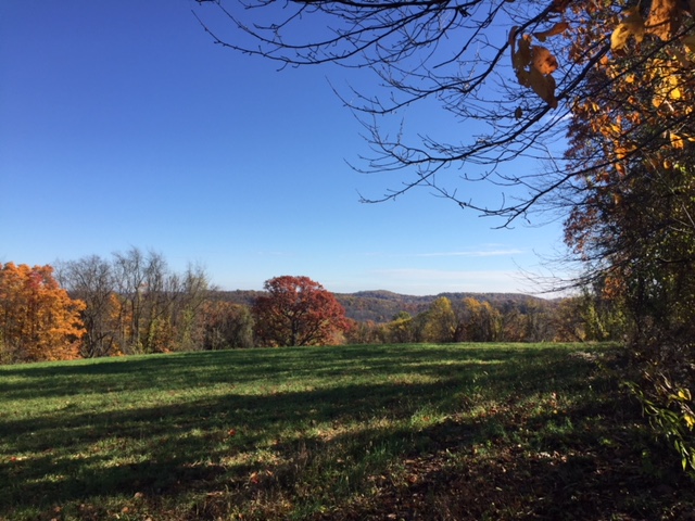
Whereas my first day out on the West Penn Trail was glorious and almost magical, this day had a dreariness to it.  Because the river at this spot becomes a lake from time to time, the banks are choked with driftwood and dead weeds.  The countryside was all shorn of autumn colors, aside from the somber, leathery oak leaves still clinging to the trees.  All was silent and gray.
But still...better than being in Pittsburgh--or any city.  Because the Conemaugh travels in a twisted coil at this spot, the trail runs a straight line over several river crossings.  Through the woods to the right of this photo, I spied a cemetery that I went off trail to explore.  Alas, there were so many "No Trespassing" signs surrounding the place that I aborted the mission.  (A few early hunters were lingering in the area, and I didn't want to get caught.)
I did ride the bike a short distance down the road where my next trip on the West Penn Trail will begin.  Farm country under gray skies.
Upon the return trip, I found an overlook with a view out onto the dam.  Not a spectacular day in the forest, but a fine one.  I hope to finish the rest of the trail--Cemetery Road to Blairsville--next week.  We'll see if that happens.  Hunting season will be in full swing, I think.

Wednesday, November 8, 2017

West Penn Trail and Saltsburg

It always amazes me how quickly the countryside east of Pittsburgh become "Central Pennsylvania," that vast land of wooded hills, and winding rivers, and crooked lanes, and ancient towns. These are the remains of an old railroad bridge over the Kiskiminetas River, along the West Penn Rail Trail, just north of Saltsburg, Pennsylvania.  When I got to the town, I opted to ride my bike northward on the trail because the town itself lay to the south.
The fall colors that usually belong to October were postponed till November by summer-like heat.  But then heavy rains washed them all away in only a matter of days.  We went straight from summer to late fall, skipping the beautiful half-season in between.  I'd never even heard of the West Penn Trail before finding it online last night, probably because it's less than 20 miles long.  Its ragged, muddy course runs along the "Kiski" River on the bed of the old West Penn Railroad.  When I struck off, at 9am, a thin sheen of ice still capped the puddles in the roadway.    
What a bracing, lovely autumn day to ride an old railroad grade.  In less than two miles, however, the puddles in the trail became reflecting pools...some of them pretty deep.  I dismounted to walk the bike around the little ponds at first, but I figured out later that many of them can just be ridden through.  I was getting discouraged and none-too-impressed with the West Penn Trail.  All the water made for slow going.  It wasn't until I got home and looked at a map that I learned the trail only runs a mile and a half north out of Saltsburg before petering out.  Most people start in Saltsburg and then head south for 16 miles or so to a spot near Blairsville.  In other words, I was riding the old railroad grade, but not a maintained rail trail. 
This was good to learn because when I'm biking on a rail trail, I like to pretend I'm a choo-choo train, and the big bogs were spoiling the illusion of flying through the countryside.  I hoped for better riding when I turned around and went south.  But first, I took a little spur trail that led up to an active rail road and another body of water called Blacklegs Run.
My bike is a 20-year old Schwinn that I bought for $45 at the a flea market at the Chautauqua Institution.  It's a good bike, but old and hardly up to doing a lot of cross-country riding.  Ah, but the day was perfect, chilly and bright, and the hinterlands were calling.
Several pretty farms opened up along the trail.  The best one was impossible to photograph through all the trees, but I could see it across the river, sitting right on the water's edge: a white clapboard farmhouse behind a row of pines, a green bank sloping down to the river, and all the white sycamores standing just at the water.  It looked like an autumnal scene from Currier and Ives--if they did fall scenes.
And then you've got the borough of Saltsburg.  This place is worth exploring.  It's typical of Central Pennsylvania, a little bit ragged and a little bit pretty.  It's situated beautifully on the Conemaugh River--which is joined by Loyalhanna Creek to form the Kiski.  And it's got some great old buildings.  This former grain store is now an outfitting place for kayakers and cyclists, but like much of the town, I wasn't sure if it was still in business.  Fall might be the "off-season" for towns like this.  It did have a fashionable-looking pub, an antique store, and a variety of shady front porches crowded with potted plants and worn wicker furniture.
Look at these great old storefronts.  
And enormous Victorian houses.
You might call Saltsburg "quaintly-grimy," like much of the state, actually.  The old stone house from the 1830s in the middle of this row is now a museum of sorts.  It was closed at 10:30am on a Wednesday morning when I went through.  I've never seen so many public benches in a town.  And none of them in use.
I liked the Presbyterian church's spire.  Better than that, I liked the Lutheran church's name: Sons of Zebedee Lutheran Church.  Really, "Sons of Zebedee"?  Sounds like something out of Harry Potter.
To really enjoy the West Penn Trail, ride south out of Saltsburg.  For almost four miles, the trail is wide, and groomed, and dry.  It follows the lazy Conemaugh River upstream toward Blairsville.
Here, there were a few maples still in leaf, which made for a scenic ride along the water's edge, a bright outdoor cathedral of yellow windows and deep blue ceilings.
After nearly four miles, the trail leaves the old railroad grade and strikes off to follow the course of Elders Run.  This is a hilly section that ends up doing some pretty major climbs before crossing Loyalhanna Lake.  I followed this until it crossed Tunnelton Road, at which time I turned back to explore Saltsburg before looking for Hankey Cemetery and heading home.  I hope to come back someday to do the lake crossing.
If only all my days could be spent like this one...and all my ways look like this.

Hankey Cemetery, 1796

Ghost chasers love the old Hankey Church Cemetery, which has sat atop its windy hill near Murrysville, Pennsylvania, since 1796.  The old Hankey Church used to stand across the road from the cemetery, in the small grassy yard.  It burned down in the 1970s under suspicious circumstances.  Notice that Michael Best, who is buried under the dark stone on the right, fought in the Revolutionary War.
Hankey Church Road is a country lane that wends through pretty hills.  The cemetery adjoins a golf course, and there are houses in the area.  There's really nothing at all spooky about the place, but people travel here from great distances to encounter paranormal phenomena--like orbs of light, cold spots, numbness, floating sensations, and visions of this specter or that.  To see just a sample of all the paranormalists' raving about this churchyard, follow this link
What does it say about our society that peaceful places give so many people the willies?  Oh, our noisy, clamorous, technologically-polluted lives.  We fear the very things that can make us well, like silence and stillness.  I thought it was a lovely place, scenic and serene.  It's an old cemetery with lots of weathered old stones and a nice view out over the surrounding countryside.  I read about this place just before Halloween, when Facebook was suggesting ghostly adventures on my page.  I think it came up on "Only In Your State" or "Atlas Obscura" or some such site.  I decided to stop off here on my way home from Saltsburg.  
Google it.  On the other side of yon picket fence is where the church sat.  That area is said to be even more haunted than the cemetery itself.  There's been a lot of drivel written about the old church site and graveyard, some of it downright histrionic.  One blogger locates the churchless churchyard "in the heart of the Appalachian Mountains," which just shows that she's never actually been here, nor even researched it on a map.  The legend about the haunting is pretty hard to buy, too.  Supposedly, at some indeterminate time in history, the minister was lynched by his congregation for committing adultery.  The adultery part isn't too terribly incredible, I suppose, but the lynching is.  Sounds to me like a legend fabricated by a high school student who was reading The Scarlet Letter in English class.
This land still belongs to the Lutheran congregation that used to have a building across the road.  Their new church is several miles away, but they still maintain both the old church site and the graveyard.  On their website, the congregation has a pretty long essay about their history.  In fact, it lists and talks about each clergyman who served the church, all the way back to 1796.  And there's no mention of any being hanged in an act of vigilante vengeance.  To be fair, the building on this site was once shared between two German-speaking denominations: Lutheran and Reformed (which are essentially continental Presbyterians).  The philandering cleric may have been the pastor of the Reformed congregation, in which case he wouldn't be mentioned on the Lutheran website.  I don't know if the old Reformed congregation still exists in some new location, or if they have a website, or if they hanged their minister long ago.  But I'm pretty sure of one thing: This place isn't haunted.  I sat at the church site and ate a tuna sandwich from Subway.  No ghosts.  

Wednesday, October 18, 2017

Quebec Run Overnight

The great beauty of Quebec Run Wild Area--Forbes State Forest--is not in grand overlooks or broad vistas, but in gentle streamside scenes such as this.  It's more than 7,000 hilly acres of forest, mostly oaks and maples with hemlocks along the many waterways.  This is up on Chestnut Ridge, the summit just east of Uniontown, and the Mason-Dixon Line forms the southern border of the "wild area."
If you come here on weekends, you'll find suburbanites aplenty, riding their mountain bikes on the hiking trails, nearly running you over, and letting their obnoxious dogs run off the leash to bark at you and sniff your genitals..  Don't come on a Friday, Saturday, or Sunday.  Come instead on a Monday, Tuesday, or Wednesday, and you'll probably have the place all to yourself--as my friend and I did this past Monday and Tuesday.
We got here at 10:30 on Monday morning, hiked till 5:00, spent the night at a pleasant spot on Mill Run, then did another trek Tuesday morning before heading home.  A barred owl serenaded us from late afternoon until sunset, but the night was quiet and still.  No noise at all except water splashing in the nearby brook and an occasional gust to rattle the dry leaves overhead.
This has been the ugliest October we've seen in my lifetime.  The trees are mainly still green, due to outrageously warm overnight temperatures.  But up on the west side of Chestnut Ridge, it felt and looked a bit like fall.  It drizzled off and on much of the first day, and nighttime temperatures dropped to 36 degrees.  So, to recap: Come to Quebec Run during the week; come in the fall; and come prepared, because these highlands can get unexpectedly cold at night.

Saturday, August 19, 2017

Braddock, as Seen from The Phantom's Revenge

 My rule at the top of all the scariest Kennywood rides is to look for Braddock.  Is the rollercoaster nearing the top of the rise?  Is it going to plunge insanely fast into gut-wrenching depths?  Are you mind-bogglingly higher than you would ever allow yourself to go on roofs, or ladders, or under any sane circumstances?  Is everyone around you screaming like a madman?  Stay calm and scan the horizon for the grand old town of Braddock.
How do you know which one is Braddock?  It'll be the one with Pittsburgh's last steel mill, just across the Monongahela River.  Just look for the smoke.  The whole region used to look like this place.  All the riverfronts in the city were crowded with factories and train tracks and smokestacks, belching clouds of noxious gray poison.  A far better way to spend a late summer afternoon is in the Monongahela National Forest of West Virginia.  Find those amazing photos by clicking here.  It's actually been a really great summer--despite the fact that Trump is still President--with far more trips than usual.  Photos from another Outer Banks adventure are here

Wednesday, August 9, 2017

A Night on Sugar Bay, Allegheny National Forest

You might not believe this, but I've never spent a night alone in the woods before.  Oh, sure, I mean I've camped in conventional campgrounds by myself, and at least one time at Ryerson Station, I was the only camper in the entire place.  I've also done a lot of backpacking with partners.  But I've never gone alone into the forest, found a spot, and said, "Here.  This is home for the night."  
It's kind of like a sex columnist admitting that he's a virgin, I suppose.  But I just never worked up the nerve to backpack alone...until yesterday.  We're at the Chautauqua Institution again--my wife loves it here--and I had to get away from all the lectures to seek the silence of the woods.  My sacred place isn't far from Chautauqua--the Allegheny National Forest--and so I went there.  The top photo is Sugar Bay in the Allegheny Reservoir--a very remote location that's traversed by the North Country Trail and the Tracy Ridge Trail System.  The second photo is my camp about 500 feet from the water's edge and a mile or two from the road.  I bushwhacked to this location; no trail comes near it, but I saw it on a map and loved the isolated look of it.
I hiked this section of the North Country Trail some years ago, in winter.  But I chose to come back with my backpack because it's one of the loneliest stretches of this great woods.  I found the most level bit of ground I could for my camp, then went down to the water's edge to set up my hammock.  This is the view from the hammock.  Fishing boats did linger in nearby waters from time to time, and the voices of fishers carried out over the water.  But all in all, the solitude was stupendous.
And it wasn't even a little bit spooky.  There were owls in the cool night, and I had a fire after the sun went down.  There was not another soul for miles and miles.  The moonlight was radiant out over the water.  Such an otherworldly beauty, especially at night.  And I saw not a sprig of poison ivy in my whole time up here!  Just before sunset, I bushwhacked to the top of a high hill behind my campsite in hopes of getting a text message off to my wife--just so she wouldn't worry.  I tried to send four different texts, and only one got through.  I didn't have cell service again until I was ten miles back inside New York State.
What's across the water over there, on the south side of Sugar Bay?  Nothing.  Absolutely nothing.  I did a lot of map research before selecting this spot, and I hope to return here by kayak someday.  There's a boat ramp pretty close by, on PA 321.
There's no such thing as level ground in this part of the world, and though I slept like a baby, I was continuously sliding toward the lake.  Oh, how I miss the Allegheny National Forest!  I know it's being ravaged by the frackers, and to still live here would be to bear the pain of witnessing its rape.  But this part of it is still pristine, almost primeval.  In fact, there's some discussion of making the Allegheny National Recreation Area (the emptiest part of the forest, within the Tracy Ridge Trail System) into a federally designated wilderness area.  I hope it succeeds; that would protect at least this large part of the forest from the fossil fuelers.  And I need to know that this place is still here, still scented by ferns and hemlocks, still ringing with birdsong in the early morning, still waiting to redeem the sorrows that I bring to it, touching them gently and making of them new life.  

Thursday, August 3, 2017

Second Thoughts about the Town Hill Tract, Buchanan State Forest

This photo was taken somewhere along Spade Road, Fulton County, and the hill rising above the quaint little farm in the foreground is Town Hill--for which the Town Hill Tract of the Buchanan State Forest is named.  My guess is that there must have been a family by the name of Town living in this area, because God knows there's not a town to name the hill after.
My visit to this portion of the forest focused almost entirely on Rays Hill, pictured here, but I'm beginning to think that I should have thought bigger.  There are two small mountains within this large tract of public land.  Because I believed in the legend of Clair Winters Road (which turned out to be essentially nonexistent as you near the summit), I focused my excursion entirely on the smaller of the two--Rays Hill.  In doing that, I ended up ignoring the larger--Town Hill--which makes up the eastern wall of the valley of Brush Creek.
The little valley between the two hills has broad, grassy meadows with wildflowers, and butterflies, and many, many deer--as well as their malevolent passengers: ticks.  If you actually come here (which you won't), be sure to tuck your pant legs into your socks and spray yourself down with repellent.  But for all the trackless hassle of bushwhacking through this mess, it's kind of a pretty place, isn't it?  It's the remoteness of it that I can't stop thinking about.  You're guaranteed to have the whole big valley all to your lonesome...which I love.
Brush Creek itself isn't much.  It's small and slow, and unlike most runs, you can't even hear it babbling silently beneath the trees.  But it does have tiny fish darting about in its currents, and jumping across it from weedy bank to weedy bank proved a challenge.
As I said in my last posting about this nearly unknown place, there's nothing about the Town Hill Tract on the Internet.  Nobody comes here except hunters.  There's a lonely sign out by the entrance to this small parking area, and a neglected notice board at the edge of the trees.  There are no trail maps on the notice board because there are essentially no trails--aside from two old farm lanes, one of which is mowed by the forest service for hunters to use, and the other is the overgrown Clair Winters Road.  Ah, but the maps show another road petering out on Town Hill at the south end of the tract.  Despite my earlier claim that there's nothing in this neck of the woods but ticks, I think I've talked myself into coming back here.  And now!  Now the Internet has two blog postings about this supremely solitary place: this one and the one I wrote earlier today.