Saturday, October 6, 2018

Standing Stone Trail: Monument Rock

This is the Monument Rock, which the Standing Stone Trail is named for.  Out west, it would be just another rock.  But around here, it's a pretty unusual thing.  It's unphotographable, surrounded as it is with branches and sitting at the jagged top of a boulder field.  Also, it's smaller than you might expect, maybe only 15 feet high.  It was nice to discover that no one had ever spray-painted it.  The kind of people who spray paint rocks are not the kind that walk a mile and a half uphill through the woods, so this stone is safe from vandals.
 Speaking of boulder fields, this place has them!  It's hard to tell, but the one pictured here is probably two acres in size.  I took the Turnpike to Fort Littleton, where I followed Sinoquipe Road, looking for Ramsey Path, a spur trail that leads up to the Standing Stone Trail and Monument Rock.  The Ramsey Trail was not easy to find, and there wasn't really any parking area to speak of.  But it was a pleasant jaunt across a patch of private ground and through the state gamelands where Monument Rock is located.
 The views along this stretch of the Standing Stone were modest, pretty but not breathtaking.  Actually, all the views on today's trek were along the other little spur trail that leads out to the rock, which is maybe a quarter mile from the main trail that bears its name.  With forty pounds on your back, and night setting in, and the urgency to find water or a campsite before dark, you could just skip this little side trip to the rock. It's less spectacular than all that.  But if you've got time and nothing on your back but a day pack, definitely make the trek.
 I haven't been maintaining this blog, even though I've continued to hike whenever possible.  I've got a lot of summer treks to post on here, and I wonder if I'll do it.  The summer has been overwhelming, and I couldn't wait to fall exhausted into the arms of my old friend October.  But I fear this is going to be another of those Octobers like we had least year: 80-degree temps until the trees fade from a dull green to bare branches with no colors in between.  Look at these photos.  It's October 6, and there's still barely any hint that it's fall.
 A few splashes of color lined the trail.  Here, the leaves nearly match the trail blaze.
I did do an overnight in the Allegheny National Forest back in July.  And a West Coast trip with a solitary overnight in the Olympia National Forest--near the Pacific Ocean.  Plus, a fantastic backpacking adventure in the Adirondacks. I may or may not post those on this blog or its out-of-state appendix.  I'm not just getting lazy; I'm also getting very tired.

Wednesday, July 4, 2018

Standing Stone Trail: An Ongoing Obsession

Just for the record, I got absolutely saturated on Jacks Mountain, where I did a straight uphill ascent, first on the barely passable Jacks Mountain Road in my car, and the rest of the way on foot.  The view from the top is worth the effort, but an effort it is!  The Standing Stone Trail runs north and south on an old dirt roadway at the ridgetop road.  At the place where it leaves the road and plunges into the woods, there's a sign (previous post) that says "Throne Room: 1.2 kilometers."  You say to yourself, "Oh, less than a mile!  No problem!"  But it's one of the longest miles I've ever hiked, straight uphill the whole way.
And if you're queasy about heights--as I tend to be--then the road up to the ridge can be a little daunting, too.  There are no railings, and the drop-off is menacing.  But there are good views along the roadway, like this one.  The boulder fields on the mountains in this area are completely natural.
Here's another view from the drive up the mountainside, looking in a generally northerly and westerly direction, I think.
Near the place where Jacks Mountain Road meets the Standing Stone Trail, this tree blocked my way.  There was another tree blocking the road a little lower down on the mountainside, but I was able to move it out of the way.  This one wouldn't budge.  So I parked the car and walked the rest of the way up.  (Yes, I drive a Kia Soul, and I know it's a college girl's car.  But mine is a stick shift, and I love it.)
This cabin sits unexpectedly near the top.  I didn't like it.  It looked to me like the kind of place where unleashed dogs come rushing at passersby.  But happily on this day no dogs, no people.
Did I happen to mention the fact that I got sopping wet up there?  Thick gray clouds rolled in swiftly and almost close enough to hit with a stone.  Despite my rain gear (including waterproof pants) I nearly to get flushed down the mountain like the Itsy-Bitsy Spider.  On the wet and slippery hike back down, I cut a live beech sapling to use as a walking stick.  I was careful to choose one that was getting starved out by its neighbors--not a tree that had a chance at survival.  But I noticed that the bark of the little tree smelled like wintergreen.  Turns out, it was a black birch, not a beech.  I stripped off all the bark when I got home and brewed it into a delicious tea.
The Standing Stone Trail maps indicate a scenic overlook a little north of the area where I did most of my hiking.  And so, though I was already pressed for time, I did a rapid sprint in that direction.  The trail northward at this spot is a little grim, passing through uninviting woods with "posted" signs and dense undergrowth.  Worse, it runs on a narrow dirt road that appears to be open to vehicles.  About a mile from the intersection with Jacks Mountain Road, there's a broad, steep pipeline easement that runs steeply up the side of the mountain to the right.  Follow the cleared swath up to be rewarded with this view to the east.  Look at the little farm valleys in the furthest distance.  I wish the day had been clear enough to get the full view, but the clouds really added something.  

Standing Stone Trail: My New Obsession

 It's been a long, long time since my last post. Sorry about that, faithful reader. Life of late hasn't lent itself to the freedoms I enjoyed in earlier times.  Work, family obligations, time constraints.  But I did manage to get a few hours of hiking done on the Standing Stone Trail in Central Pennsylvania.  This is the view from an area along the trail called "The Throne Room."  In the distance you can see several long ridgelines in the "Ridge and Valley Province" of the state.  In order of proximity, you see: Blacklog Mountain, the ominously named Shade Mountain, and Tuscarora Mountain in the furthest, mistiest distance.
 I've become obsessed with the Standing Stone Trail--see my last post.  And so, on June 24, a day of glowering skies and torrential downpours, I drove three hours to the center of the state to explore some of the trail's visual highlights.  On a clear day, the view would have been far better, but you have to make do with the day you're given.
 Planning a long-distance trek is almost as much fun as actually doing one.  In some cases, it's even more fun because you get to do it from the comfort of your laptop, without a thirty pound pack on your back and hundreds of yards of sharp rocks to scramble across.  And so, I've been planning a "through hike" on this trail ever since March.  But didn't make it back out here to check some things out until June.  I went to a hamlet called Barneytown and followed Jacks Mountain Road almost to a place where it joined the trail.  However, recent rainstorms had downed some trees across the road, and one of them I was unable to move.  So I parked at the blocked spot in the road and walked the rest of the way to the summit and the trail.
 This boulder field is known as The Hall of the Mountain King.  Aside from evoking vaguely familiar tunes from interminable Wagnerian operas, the area is hell on the ankles and knees.  It would be even harder to cross on a hot day with snakes on the rocks.  The Standing Stone runs 84 miles from Cowan's Gap State Park to Greenwood Furnace State Park, following the narrow summits of the several mountains wherever possible.  It does descend briefly into the little trail towns of Three Springs and Mapleton.  There's some roadside hiking involved, and legal camping is relatively rare along the way--not to mention waters sources.   
In other words, it's like a mini-Appalachian Trail.  Or maybe an alternative to the AT for people who don't like crowds and who don't actually want to quit their jobs in order to hike full time.  I think I could do the whole thing in 8 to 10 days.  Photos don't do it justice.  In any case, the Standing Stone Trail is part of the Great Eastern Trail--a lesser traveled and more scenic alternative to the AT.

Sunday, March 11, 2018

Standing Stone Trail and the Thousand Steps, Part II

 The previous post about the brilliant Thousand Steps Trail up the side of Jacks Mountain seemed woefully inadequate.  And so I decided to add a few more pictures.  Here is the view from the eastern and less heavily visited overlook.  The town in the distance is Mt. Union.  I had this vista all to myself for about half an hour, and I never encountered anyone on the trail to or from it.
 The path up to the more popular western overlook passes behind the old railroad building.  I thought it made a curious spectacle on the mountainside.
 Although there was very little snow left on the lower reaches of the mountain, there was still plenty at the top.  This is the much-visited western overlook, which is in the same location as the old rock quarry whose employees used to trudge the Thousand Steps on their way to and from work.  The town seen here is Mapleton.  These little mountain towns are curious places.  I drove into Mt. Union just to look around.  It was a decent enough place with those big old Central Pennsylvania houses, a Dollar General, a McDonald's, most of the standard religious franchises--including one very Russian-looking onion dome.  The main street didn't have a lot of empty storefronts, which is always a good sign.  I liked the town.
As I explored the unmarked old railroad grades that crisscross the upper reaches of Jacks Mountain, views like these were always visible through the trees.  In the summer, there wouldn't be much to see, but it was a rare pleasure to catch an eyeful of distant country through the bare branches.  It made for a dramatic backdrop to my regular woodland thinking.

Standing Stone Trail and the Thousand Steps

 Spent a magnificent, cold March day making a pilgrimage to the Thousand Steps and the Standing Stone Trail in Central Pennsylvania.  It was a good 2.5 hour drive from home--closer to Harrisburg than to Pittsburgh--and it would have taken much longer if I'd driven anywhere near the speed limit.
 It was spectacular and well worth the long drive down old US 22 through coal country and into the lovely mountains and quaint villages in the middle of the state.  In the 1930s, men working in a rock quarry near the top of Jacks Mountain had to walk up 1,000 hand-dug stone steps to their workplace.  And then, after a workday of hauling rocks, they had to descend by the same route.  It is a challenging hike even without laboring in a rock quarry both after and before.  Look how steep these steps are!  They wend their circuitous route all the way up to some really great views at the old quarry.
On the Thousand Steps Trail, you gain an elevation of 800 feet in about one mile.  It's practically a stone ladder tipped against the mountainside.  Here's the view from a little less than halfway up.  
 I was easily the oldest person on the trail that day--a chilly Saturday with lots of sun.  There were many other hikers out, which is one disadvantage of this trail, but almost all of them were considerably younger than me.  I think many of them were students at nearby Juniata College.  Older folks probably see this place as heart-attack-hill.
 I don't typically like high-traffic trails, but once you get away from the steps and the overlook, there's lots of solitude up here on the mountain.  Many old trails run along the flanks of Jacks Mountain.  They form a network of terraces that you only see once you're on top of them; you can't see them from below.  These are the old beds of tiny railroad tracks that were used for transporting lumber and stone down to the valley.  You'd think they'd have let the quarry-workers hitch a ride up and down the mountain!
 One advantage of this otherwise crowded outdoor trek is that most people wouldn't inflict the climb on their dogs.  This area was dog-free...except for a tiny bichon who seemed to be maneuvering the steps just fine.
 Once you reach the top, there are two overlooks--an eastern one looking off toward the hardscrabble little borough of Mt. Union, and a much more popular western one looking off toward the village of Mapleton.  The eastern one was my favorite, mostly because I was the only person who visited it.  But the view is less dramatic, and it is not pictured here.  (See the post above, "Standing Stone Trail and the Thousand Steps, Part II.)
This view of Mapleton is from the path toward the eastern overlook.  I'm not really sure what designates a place as an overlook; the views were just about everywhere.
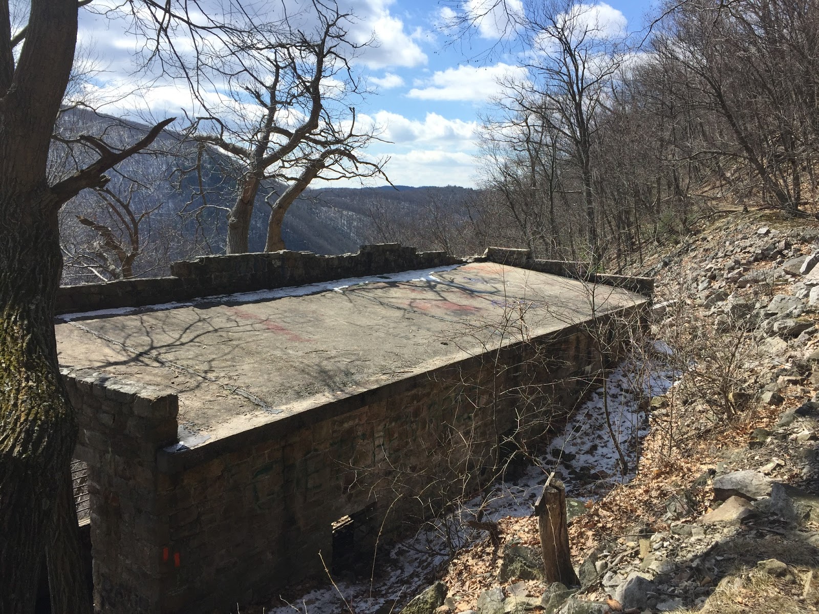
 The tiny railroads that used to meander up the sides of this mountain were called "dinky lines," because both the trains and their pathways were small.  I'm not sure what the function of this old structure might have been, but it was clearly linked to the railroads and the hauling of stone.
 It's my strange lot in life to see an interior like this and think, "Hmm, that would make an interesting church."  Not sure how you'd get all the little old ladies up to it, but it's my other strange lot in life to spend a lot of time in empty churches...
 The view out the empty doorway to the mountain across the Juniata valley is reminiscent of New Mexico.  But on the whole, this trek reminded me a lot of the Asheville area.  The towns in the valleys below weren't quite as fashionable as Asheville, but then again, Asheville wasn't always fashionable.
  And here's the view from near the old rock quarry.  This is looking more or less westward, toward the village of Mapleton.  The Juniata River runs through the valley.  I honestly found myself holding onto trees up here on the steep mountainsides for fear of falling--which is pretty ridiculous.  My fear of heights is getting so much worse with age.
 This lesser view is also from near the quarry, looking a different direction.  The boulder fields on the sides of these mountains are strange but entirely natural.  They're why through-hikers on the Appalachian Trail call this state Rocksylvania.  
See the number 1,000 written on this step?  Every 100th step is numbered in order to help you gauge your progress, and there are actually a few more than 1,000.  The numbering didn't always come out exactly like mine, but it was a nice thing to have some idea of how close you were to the top--or the bottom.  I'm not sure which was harder, the long upward climb with its gasping and panting, or the long downhill climb with its incredible strain on aging knees.  But if you go one direction, you'll have to go the other...so bring a stout walking stick.  It's the only railing you'll get on these stairs.
I spent much of my time up top just exploring the mountain.  The Standing Stone Trail runs 84 miles, from Cowan's Gap State Park to Greenwood Furnace State Park.  It traverses truly beautiful country and has some of the best upland scenery of any trail in the state.  The Standing Stone is part of the Great Eastern Trail, which is a network of smaller, less-busy trails that are being touted as an alternative to the Appalachian Trail--which is not only getting very crowded, but which runs through less scenic countryside.  I really enjoyed driving out in this wild part of Pennsylvania.  And it was a balm to my soul to spend the day on Jacks Mountain.  

Wednesday, January 24, 2018

A Return to Winter Cabins

A bleak and a dreary day to be in the forest, but any day amongst the trees is better than a day away from them.  I had no intention to return to the winter cabins today--the ones I discovered last January.  My aim was Beam Rocks, with their view out over the wintry countryside to the east.  And I'd have made it up the slippery, snowy road even in my pitiful little Kia Soul--if not for some oblivious, inconsiderate jogger.
I was chugging nicely up the mountain, despite the baloney-skin tires and the car's awful handling, when I saw a woman jogging down the middle of the snow-covered road.  She must have heard me coming up behind her, but she refused to make room, so I had to break my stride, dropping the car down into second gear, then first gear.  (The car's a stick, which usually completely makes up for its poor winter performance; I hope to never drive an automatic again.)  Of course, there was no recovering from that loss of momentum on the snow.  The tires begin to roll and skid, gaining no traction.  I was so mad at that clueless woman.  Why couldn't she have just moved four feet to one side?  But there was no way around it.  I had to put the thing in neutral and drift backward down the slippery hill till I could turn the car around and seek another destination.  Hence the winter cabins.
You have to hike into these sites, unless you come in high summer, when the narrow dirt roadways are dry.  But it's a good hike, about an hour and fifteen minutes from the road that runs through Linn Run State Park.  The little one-room cabin in the second and third photos is just a place I sometimes admire when I'm hiking out this direction.  What I wouldn't give to have a place like this!  The family name "Kalp" is written across the belly of the craftsy 1980s-style wooden goose above the door.  If this were my place, though, I'd surround it with a whole lot less rusting debris, and I'd put curtains in the windows.  (The thought of some woods-walker seeing into my cabin at night just creeps me the hell out.)  
This other cabin belongs to the Forbes State Forest, and I actually have an email from a ranger saying that the public is allowed to use it for free.  It was deeded to the PADCNR, and they don't really seem to know what to do with it.  Last time I was out this direction, I bemoaned the fact that--although all the cabins were closed for the winter--they didn't have the peaceful seclusion of being snowbound.  It was eerily warm that January, and the locations were easily accessible to anyone willing to walk a few miles over neglected trails.  Today, winter was putting in a cameo appearance...but still nothing dramatic.  After an incredibly cold spell earlier this month, January and February are all set now to return to their new default: chilly, gray climate change endless Novemberesque season of drear.
 The place has changed a little since the last time I was here.  Someone removed the big picnic table, and the jumbo bottle of Cuervo is gone.  But the same frequent visitor keeps his pots on the mantel and his clay pigeons in one corner.  The silence here was perfect, broken only by an occasional gust of cold wind, tugging at the walls and windows.  It was surprisingly cozy just to settle into the little white plastic couch, and there I sat to relish the solitude and quiet.  I read a book, stared at the walls, wondered what it would be like to spend a night in the place.
 Honestly, if I were to start frequenting this two-story cabin, I'd need to make it feel a little more comfortable.  I'd have to pack in some sheets or towels to place over the windows at night.  There's a broom in the corner near the staircase; I'd definitely have to put the thing to work.  Aside from that, an air mattress, a lamp, some blankets, some books, a kettle and French press coffee maker...then we'd be good.
This is the upper floor, the bedroom.  Like the lower level, it's completely unfinished, but what potential!  How is it that I've never been to this place when the trees are in leaf?  Maybe it only appears when skies are gray and trees are bare.