Wednesday, March 27, 2013

More Scenes from the Mon Valley


Carrie Furnace & Rankin, PA

 This is the famed Carrie Furnace, which sits derelict on the banks of the Monongahela River in Rankin, PA. At the height of its glory, the Carrie Furnace cranked out 1250 tons of iron per day.  Getting close enough to take pictures is no small task.  
 The land all around the old factory is closed off with a chain link fence and plenty of "No Trespassing" signs.  Apparently the county is redeveloping this area into a riverside park and historic site.  The plant was constructed in 1884 as part of the immense Homestead Steel Works--the bulk of which was across the river.  The Carrie Furnace was in operation until 1982, though only furnaces #6 and #7 remain.  
 Despite my thorough pre-trek research on Google Earth, it actually took some effort to find access to this place.  I ended up going back into Braddock, then following a meandering brick lane through the flat industrial wastes along the river.  You pass under the Rankin Bridge--which most Pittsburghers know as the gateway to Kennywood.  When the road ends at a gate, you park and walk down the railroad tracks.  There's a drop-off to one side of the tracks; down in that murky chasm there runs a spooky little road that seems inaccessible to cars (above photo).  This eerie pedestrian tunnel probably runs up the hillside to the workers' neighborhoods in Rankin.  The date above the entrance is 1932.  
 When Soviet leader Brezhnev visited the United States in 1973, one of the things he most wanted to see was the great Homestead Steelworks, which at the time was the largest steel factory in the world.  Aside from a line of old smokestacks in a mall parking lot across the river, this all that remains.  
 Twice, as I was walking along the tracks, trains came rumbling past and forced me into the gravelly margins.   On the trek back to the car, I tried in vain to outrun the train.  It sure feels weird to be running down the tracks with a big old Conrail locomotive barreling up behind you.  Also, there were about half a dozen workmen on the grounds of the factory, presumably turning the place into a park.  
 This is the old "Hot Metal Bridge" over the Monongahela River, as seen from a tiny city park on the hillside up in Rankin.  The Hot Metal was never a public thoroughfare; it was used solely to transport hot metal between the Carrie Furnace and the main complex of the Homestead Works.  
 For a little while, I considered ranking Rankin among the "Iconic Towns of the Mon Valley" and categorizing this article with that series (below).  But honestly, Rankin was never really one of the big satellite cities in the region.  It's not an unpleasant place.  Despite a pretty high rate of poverty, Rankin has fewer abandoned buildings than its closest neighbor, Braddock.  And some stretches of 3rd Avenue were especially nice; they reminded me of Belgium (last photo).  But the fact is that Rankin was always pretty much residential and industrial--unlike Braddock, McKeesport, Clairton, and Duquesne, which were full-scale cities in their own rights.  Rankin had the Carrie Furnace, but obviously never had much in the way of a business district, or commercial buildings, or even stately churches--aside from the onion-domed St. Michael's Orthodox.
Getting into Rankin is easier than getting out.  Most of the town's brick streets seem to come to dead ends at warehouses or small factories.  I had to follow a city bus as it wended its way through Swissvale and back to Braddock Avenue. All in all, Rankin seemed like a pleasant enough place, even if the white police officer slowed down and stared at me hard as he drove past.  

Wednesday, March 20, 2013

Highland Park, Pittsburgh

One thing I like about the city is its pervasive, ignorable beauty.  Statues, and stone garlands, and Doric columns in places where no one is looking.   
You rarely hear about Highland Park.  The adjacent neighborhood by the same name is relatively well-known, but the park itself exists in the shadow of the more popular Schenley and Frick parks.  Pittsburgh really has four historic "planned" parks.  Schenley is the crowning glory.  Frick is where wealthy urbanites let their dogs run off the leash.  The smallest and most urban of the four is Allegheny Commons, on the North Side.  There you can still see homeless people sleeping on benches.  Highland Park is often lost in the shuffle, but it too is a large, historic, "planned" urban park with lots of glorious details and flourishes.  Of course, there are many smaller parks throughout the city, especially downtown.  And the most famous park of all--"The Point"--is actually one of the newest...despite its location at the site of the original French and British forts.  
City parks don't typically satisfy my need for wild spaces, but the turn-of-the-century statuary is always a curiosity.  And there is something kind of nice about grassy hillsides beneath large shade trees.  Highland Park is one of those ambitious city parks that proved too big to maintain, so they put the zoo and two reservoirs in it to fill up some of the space.  

Tuesday, March 19, 2013

Lake / Forest Trails Loop, Raccoon Creek

 What a perfect day to be back on the trails at Raccoon Creek, after such a long absence.  Intermittently sunny, blustery, chilly.  I've learned my lesson: it's nice to know that Hillman and the state game lands are still there, but Raccoon Creek is the only serious hiking destination within half an hour of the city.  
 I took a friend into the woods with me this time around--which is rare because I typically hike in order to get away from people.  But this is a guy who needs more wilderness in his life, and so I wanted to get him hooked on the subtle beauty of Raccoon Creek.  Despite living in Pittsburgh for more than ten years, he had never been there.  The best place to go if you want to give someone a brief overview of the park is the Lake Trail / Forest Trail loop.  It's four miles long, takes about two hours, and passes along the edge of the big lake, up into the highlands, and through some very scenic stream valleys.  There are several historic ruins hidden in the trees along the edge of the path, and for the sake of visibility, a clear March day is perfect for seeing them.  
 Above is a springhouse that's designed more like a holding cell for criminals.  It's made of poured concrete, so probably not much more than 100 years old.  This third photo is the cellar of some long-ago homestead.  I've probably photographed this thing a dozen times.  
But further west on the Forest Trail, I discovered this strange foundation-looking structure that I'd never noticed before.  It sits further from the path, and would be hard to notice in high summer.  It looks almost as if someone collected up many of the fieldstone blocks that were scattered about this part of the forest and tried to assemble them into a little shelter.  The walls are about three feet high, and precariously balanced.  The guidebook mentions the remains of a stone quarry, which this may be. 

It was kind of fun hiking with a companion for a change, but I don't think he really even noticed all the cool features at Raccoon.  Of course, I didn't either until after I resigned myself to the place.  

Tuesday, March 12, 2013

McKees Rocks: An Onion-Domed Diamond...in the Rough

HELLO. The below article was written in 2013, and it has elicited more comments than any other article ever published on this obscure blog.  The editorial board here at Snow and Jaggers regrets any offense that it has caused to many folks who know and love the community of McKees Rocks.  We really do!  And yet, we leave it here on the blog because to take it down would mean eliminating all of the comments that people have made here about their beloved community.  When the article was written, the author was not fully aware of the complicated feelings (memories, hopes, losses, dreams...) that surround all communities where people try to make their lives--especially those communities that have fallen on hard times.  The author was also less than sensitive to the struggles of ethnic and racial minorities in McKees Rocks.  If it helps at all, the writer has since been fired.  The last anyone heard, that author was writing speeches for Ted Cruz.  😕  (Not really.)

        McKees Rocks is to Pittsburgh what Jersey City is to New York: a disreputable younger brother across the river whose name you know, but you're not sure why.  Like an overshadowed sibling, it has its own charms and worthwhile traits, but most people never discover them.  Wikipedia doesn't mention this, but it was here that Pierre Chartiers--a half-Shawnee, half-French fur-trader--had his trading post in the 1750s.
           In local shorthand, this place is called "The Rocks."  It's interesting that Pittsburgh is placed between two towns named after the McKee Family, and both of those towns are located at confluences where large tributaries join up with one of the Burgh's three great rivers.
           McKeesport, of course, is to the southeast of the city at the spot where the Youghiogheny (or Yawk) joins the Monongahela.  McKees Rocks is northwest of the city at the juncture of Chartiers Creek with the Ohio.  (I've made the argument many times that Chartiers Creek would be called "a river" next door in the Buckeye State...)
           I'm sure people make jokes about The Rocks being "on the rocks," but I found the place pleasant enough.  Like many satellite cities in the Pittsburgh region, it is plenty gritty and struggling with a loss of identity and sustainable industry.  And yet, it's a hilly town with beautiful churches and public buildings, steep brick streets, and access to two rivers.
          Here again, it would be a misnomer to call this place a "suburb" of Pittsburgh.  It's a satellite city with its own unique identity and feel.  Consider the ethnic makeup.  The churches in the Onion Domed neighborhood--a part of town known even to my iPhone as "The Bottoms"--are Ukrainian Orthodox, Byzantine Catholic, and Orthodox Church in America--which is largely Russian.  So this place is "The Rocks Bottoms"?  
           The problem with urban ghost towning is that there's always someone watching you when you try to slip into an abandoned building.  And, of course, you're more likely to come across a drug addict or mentally ill homeless person once you get inside.  Here in The Bottoms, a guy started to follow me around, assuming that I was up to no good.  I managed to lose him in an alley, but honestly, I think I could have taken him.
         And he was right anyway: I was up to no good.  Slinking around, admiring the decay, wondering about the lives of those 19th century Slavs and Serbs who made their way to this place, banded together, tried like hell to keep their mother tongues alive, along with their cuisine, and their customs.  They erected onion dome churches to stand on the skyline of this old river town, reminiscent of the domes that preside over the far-off steppes and tundras of their native countryside.  But fields and forests were off limits to them in this new land; around here, the landowners were all of Western European descent.  So they huddled with their own kind in dense urban neighborhoods.  They dug their vegetable gardens in the tiny backyards: beets, and potatoes, and cabbages, and all the cold-tolerant greens of the East.  Then--having spent years dreaming about a new way of life in this place--they set about dreaming of the old way of life in the place they left behind.  Here and now, their greatest urgency was to keep alive the traditions of the old country, clinging to a fading identity.

          Here's the Pittsburgh skyline as seen from McKees Rocks with the Ohio River in the middle ground.  I'll come back with my kayak when the weather is better.

A Woodland Return

 Today my heart was pulled in too many directions.  I wait all week for my day off, and sometimes when it comes, it finds me still mired in indecision about where to trek.  I wanted to put my kayak into Chartiers Creek at the spot where it empties into the Ohio River, at McKees Rocks (not to be confused with McKeesport).  I wanted to make my annual hiking trip back down at Ryerson Station State Park.  And I wanted to revisit the Monongahela Valley to spend a little more time in McKeesport.  I'm increasingly convinced that I would really like the place if I explored it longer.  
 But with so many competing claims upon my several hours of freedom (and upon my limited imagination) I ended up trying to do too much.  It was too cold to kayak, so I set off for McKees Rocks just to scout out the boat ramp that I'd seen on Google Earth.  Instead of putting into the water, I reasoned, I would get all my locations planned for a warmer day.  I live in the middle of the Chartiers Creek Valley, and someday I'd like to paddle it from Canonsburg all the way to its mouth at McKees Rocks.  I was also checking out the boat ramp on the Ohio River because I'm wondering what it would be like to paddle over to Brunot Island, which is owned by Duquesne Light, and unreachable by car.  And so, my trip to The Rocks was exploratory.  Once there, I also looked around the Onion Dome Ghetto of that town--described above.  
With a few hours of liberty left, I decided to make for the nearest patch of woodlands.  It had been so long since I'd had a good, sylvan hike that I felt almost obligated to try it again.  These Mon Valley adventures have been a lot of fun, but they're a completely different kind of trek.  Going to the woods today was like forcing myself to work out.  I thought my spirit needed it, even though I didn't want to do it.

Hillman State Park is the closest patch of real woods to Pittsburgh.  It's not beautiful by any reckoning, but it is possible to find solitude there, but it's close.  From McKees Rocks, I was easily on the trails in less than half an hour.  And yet, it almost always pays to spend an extra ten minutes in the car and go all the way to Raccoon Creek.  The woods at Hillman are thin, wispy, ragged, and littered with all kinds of beverage containers and cigarette butts.  There are some vaguely scenic spots, but not in March.  Right now the whole place is gray and haunted.  It wasn't even all that great to get back to the woods...not these woods.  A little more focus really could have made this day a success...

Wednesday, March 6, 2013

Iconic Towns of the Mon Valley: A Backward Glance

Clairton, PA
The four blog articles that follow are a celebration of the "darkly lovely" old steel towns in the valley of the Monongahela River.  I call them "iconic" because they do stand as icons in this region.  Each of these towns was known for something unique.  They enjoyed their moment in the sun, famous around the world for their wealth, for their productivity, and--most of all--for their product: steel.  This one made steel rods; that one made steel thingamajigs; the other one made steel whatchamacallits.  The names of these towns were whispered like prayers by many Greeks, and Russians, and Serbs, and Croats, and Poles.  To them, this valley was the land of opportunity, the living dream, for which they would trade everything they knew.  No one longs to come here now...except melancholy trespassers like me.  
Duquesne, PA
 Time constraints limited me to the downriver towns in Allegheny County.  (Remember that the Mon is one of only three major rivers in the world that flows northward.)  There are other towns upriver and to the south, and some of them are just as storied as the places I've visited: Donora, Monessen, Charleroi, and Brownsville.  In fact, the historic town of Brownsville is one of the oldest, most fascinating municipalities in the western half of the state.  Maybe someday...
Duquesne, PA
 The Monongahela is a wide river that passes between steep hills and old countryside.  The word "Monongahela" even means "steep-banked river" in some long-forgotten native tongue.  In the 18th century, before the advent of coal and steel, the Valley was famous for its rye whiskey.  "Monongahela Rye" was prized in the colonial cities along the coast.  Who knows--now that the steel mills are mostly gone, maybe distilleries would be a way to embrace the future and the past at once? 
Duquesne, PA
 This valley is well worth many years of discovery.  A city-planning document published in 1988 talks about ways to remake the valley after the departure of its defining industry.  This old study reaches some of the same conclusions that I reached in my four town visits: 1) The Valley is geographically isolated, with no major roadways in or out; 2) Industrial sites--whether active or inactive--separate the towns from their rivers; 3) and morale in these towns is low.  If you look at them on Google Earth, or any detailed map, you'll see that each town has its broad expanse of waterside flats where the industrial complexes once stood...or still stand.  Proximity to water is just good for people's emotional health.  Among other things, the presence of water creates a sense of connectedness to the larger world.  But these industrial sites join with busy roadways and railroads to cut the towns off from their river.  They also serve as a demoralizing reminder of lost identity.  And yet, many of those who have remained here are committed to their communities.
Clairton, PA
 These places make me think of the line from TS Eliot: "This is how the world will end, not with a bang but a whimper."  These towns look as if battles have been fought in them, but outright violence didn't do this; all their ruination is due to simple neglect.  If foreign armies came to do to our prosperous, historic communities what we ourselves have done to them, we would take up arms and shed our blood in their defense.  These towns have been decimated and left half abandoned, and it is our doing.
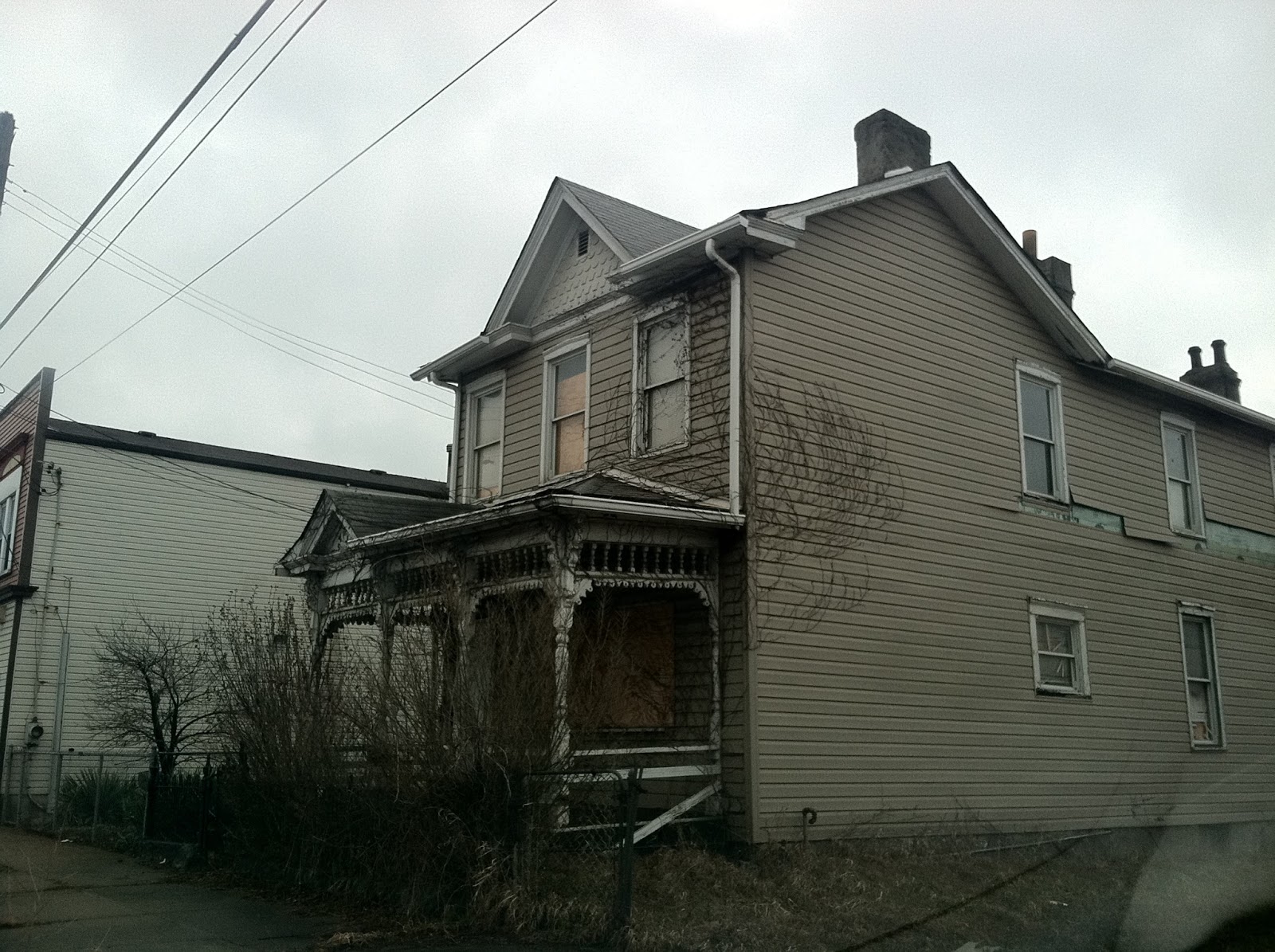
Braddock, PA
 Despite their almost European stateliness and humanness, these Mon Valley cities are in many places ghostly ruins, haunted, melancholy, bleak.  Vacant windows, boarded up storefronts, old businesses all locked up tight with ancient merchandise still on the shelves.  Twenty years ago, they were just waiting for the people to return.  But in the meantime, the roofs started to go, and now they're waiting to disappear.  
Duquesne, PA
 The collapse of the steel industry is a complex economic reality.  My suspicion is that many factors contributed to it: a diminishing supply of ore; increased labor costs; a growing sense of the environmental impact.  But at its heart, I wouldn't be surprised to learn that these communities were sacrificed to corporate greed.  It was just cheaper to manufacture things elsewhere.    
McKeesport, PA
 This is the Frankenstein's Monster of our own making.  Greed will be our undoing, I promise.  It will despoil the planet long before we've stopped needing it.  Greed will make our water unusable and our air unbreathable.  Where will we go then?  Where will we flee?  
Clairton, PA
 If we cannot treasure what we have built, if we cannot retain a sense of pride in the work of our hands, then we will be given over to the empty passions of mindless men.  Give me more.  Give me bigger.  Give me newer.  
Clairton, PA
The Valley of the Monongahela River is beautiful...in its way.  Its towns are like open air museums, where little bits of ancient Americana lie rusting in the weeds and in the cracked windows of forsaken stores.  It's a place where Nature--for all her long humiliation--is retaking possession of the land.  There is a beauty to be discovered here.  There are lessons to be learned, too.  
Clairton, PA
Anybody remember Dutch Boy Paints?  

Well, just because I'm a melancholy ex-English teacher, here are Lord Byron's thoughts on the matter:

They say that hope is happiness;
But genuine love must prize the past,
And memory wakes the thoughts that bless;
They rose the first--they set the last.

And all that memory loves the most
Was once our only hope to be,
And all that hope adored and lost
Hath melted into memory.

Alas!  It is delusion all:
The future cheats us from afar,
Nor can we be what we recall,
Nor dare we think on what we are.

1815

Tuesday, March 5, 2013

Iconic Towns of the Mon Valley: Clairton, PA

 This town's real moment of fame came in the 1978 film, The Deer Hunter, when one of the characters desperately tried to get an international telephone call through from Vietnam to Clairton, Pennsylvania.  It's been so long since I've watched that old classic movie that I can't remember which character was placing the call.  But I do remember that the American GIs in the film were all deer hunters of Eastern European stock, and that much seems consistent with the Clairton I discovered...with its "Croatia Club" and its many pickup trucks.    
 Clairton is the town that outsiders wrongly expect Pittsburgh to be: smoky, smelly, shabby, and poor.  US Steel still has a large, operational "coke works" in this town.  In fact, as you begin your descent into the valley of the Monongahela River--top photo--the sight and smell of the factory emissions are almost shocking.  It's not a bad smell necessarily, but it is dangerous.  Clairton has the poorest air quality and the highest rates of lung cancer in the region.  
Unlike Duquesne, the folks in Clairton don't mind slowing down to stare at a stranger as they drive past.  The central business district is mostly derelict.  But you'll still find a handful of old white guys who park their American-made, 80s-model bangers along the street.  They're making their way to the few open bars.  
It's interesting that both Braddock and Clairton have kept their big factories, but their decline is still as bad as that of any other town on the Mon.  I believe it's because nobody wants to live in an industrial zone.  Though the Clairton Works still provides lots of jobs, the workers mainly live in West Mifflin, where the air is less toxic and the housing is newer.  
 Clairton dubbed itself "The City of Prayer" in response to the Supreme Court's 1963 ruling against prayer in public schools.  The moniker could be ironic, considering that Clairton is one of the few towns in the Mon Valley that isn't dominated by onion domed churches.  But if by "prayer" they mean the final refuge of the desperate, then it could be an appropriate enough nickname.  Whole blocks of this town will surely be pulled down in ten years or so.  And yet, though the commercial buildings tend to be empty, a greater percentage of the houses here appear to be occupied.  
 This nice abandoned house sits on a steep hillside, overlooking the factory.  
 Like other towns on the Monongahela, Clairton is a place of old, old mysteries, porches loaded down with decades of debris, houses and stores that have been locked up tight for years, concealing the leftover toys of forgotten childhoods, faded wedding photos, foreign-looking heirlooms from the old country, delicate old china, once-treasured books in Cyrillic script, and trinkets, and articles of clothing.  All the abandoned dreams, the disappearing memories that this town hides!  Click on this photo (as always) to enlarge it.  I'm guessing there's some Irish pride in these parts.  
 This is exactly the kind of living situation that causes people to leave the Mon Valley: 30-some steps up to the front door of a rickety old house with no driveway and a really steep lawn.  I half expected Laurel and Hardy to pull up at the foot of these stairs with a piano in a delivery van.  
This cemetery is the oldest in the city, and it sits on a little hillock, completely overshadowed by the coke works.  Unseen railroad tracks pass at the foot of the hill, between the graveyard and the industrial complex.  The oldest grave belongs to Benjamin Kuykendall, earliest European settler, who arrived here in 1754 and was buried in 1785.  The whole region was a pristine wilderness then, and this little graveyard plot was nestled among forest and field, overlooking the placid Monongahela River.  How far!  How far the world has come and gone since those days!
The cemetery hill is almost scenic when you turn your back to the coke works and face westward.  Unfortunately for these hapless dead, their headstones are facing east, toward "those dark, satanic mills."  In simpler times, graves were designed to face the rising sun.  Old timers used to believe that Christ would someday return to earth and sweep across the skies from east to west, awakening the dead for the final judgement.  For that reason, they wanted to be buried in such a way that, when they rose, they would be facing him.  It reminds me of those haunting words I know by heart: "In the sure and certain hope of the resurrection to eternal life in Jesus Christ our Lord, we commend to Almighty God the dead, and commit this body to the ground.  Earth to earth, ashes to ashes, and dust to dust"  Yes, Clairton has ashes and dust aplenty.  But somehow, I think resurrection is very far from this place.  

Iconic Towns of the Mon Valley: McKeesport, PA

  McKeesport is situated nicely at the confluence of the Youghiogheny and Monongahela rivers.  It's the largest of the old mill towns in the Mon Valley, and a grimmer urban landscape you will not find...unless you sneak into the abandoned cities around Chernobyl.  Even beneath sunny skies, in the warm temperatures of early spring, this place is ghostly.  Though, I did chuckle when I drove past a storefront church here called "The Armor of God Worship Center."  
 The famed Seneca Indian Queen Alliquippa held court somewhere in this area, and a young George Washington came here in the 1750s to pay her homage.  The town was settled in 1795 by a ferry operator named McKee.  
 At its height, in 1940, this bedraggled old city was home to 55,000 souls, and it truly was a prosperous, well-known city in its own right--entirely apart from Pittsburgh.  It was here in 1947 that Kennedy debated Nixon, though neither man knew that they would meet again in the presidential debates of 1960.  (But hell, every guy in D.C. has his eye on that eventual possibility.)  Here you'll find the shells of old department stores, glorious churches--many of them onion domes--ramshackle rowhouses, and festering mansions.  
 Today, there are only about 19,000 hangers-on left in McKeesport, a full quarter of them living below the poverty line.  Maybe I liked this city less than the other towns along the Mon because there's just so much of it.  It's not as easy to explore on foot as Braddock or, to a lesser degree, Duquesne.  The sign that greets you as you enter the central business district encourages you to "Discover McKeesport!"  
 Worst of all, the downtown and the residential areas seem entirely disconnected from the rivers that give the city its identity.  A broad, busy thoroughfare separates the town itself from the old industrial zone, where the factory used to stand on the banks of the Mon.  In most areas of town, you wouldn't even know that there are two rivers nearby.  The city's layout isn't in harmony with the topography, somehow.  
 And yet, some effort has been made to develop recreational areas adjacent to the Youghiogheny...known in Western Pennsylvania as "The Yawk."  Rivers are the lifeblood of civilizations.  Every river has its own identity.  The Mon was the river of production, manufacturing, and the blue collar attainment of the American Dream.  Now, it's the river of gritty mill towns.  But the Yawk remains the legendary river of wilderness adventure and whitewater rafting.  Even McKeesport's decay can't entirely diminish the Yawk's wild appeal.  
 The bottom three photos are large, abandoned homes in the once-affluent neighborhood of Shaw Avenue.   I first saw pictures of some of these houses on a site called "Discovering Historic Pittsburgh," and so I sought them out.   It's surely true that I didn't give McKeesport a fair hearing.  There's a large, scenic cemetery on the north edge of town, and the views from the bridges are apparently nice.  But all in all, I'd rather be in Braddock...or Duquesne...or maybe even Clairton.  For some reason, I'm most drawn to Duquesne.