
Had a beautiful day at Hillman State Park, surprisingly nice, replete with new discoveries and the traditional Hillman-hour-of-being lost—frantically, irritatingly, circling round and round lost! That part, the thing about being lost, is classic Hillman. Hillman is a place I used to visit when I didn’t have time to go anywhere better. It was a total crapshoot, since the trails were laid out for mountain bikers, not hikers, and they zigzagged over the strange terrain with no real purpose except to create an exciting ride with lots of ups and downs.
Also, the trails were unmarked, so even though I only went there for a quick trek, I’d always end up getting lost—which takes a lot of fun out of hiking and ends up taking more time than anticipated.

On top of these frustrations, the place was just not much to my liking: poison ivy, tree-strangling vines, ticks. It’s entirely reclaimed strip mines, so the topography is great for mountain biking, but strangely alien to the hiker. Plus, the thinnish soil makes for a less robust forest. There are lots of big, grassy meadows. But I returned to the southeastern quadrant of the park today and—much to my surprise—I found the trails named and blazed! Look at this signage.

Not sure why I went back to the southeastern part of the park. It’s always been the area with the most tree-cover. But at Hillman, the more trees you have, the more lost you can get! It was such a joy to see that someone is putting a little effort into making this park usable. Although it’s almost as big as its more-glamorous neighbor, Raccoon Creek State Park, it’s always been administered as a sort of disreputable younger sibling to that park and by the same over-worked rangers. I mean, there’s only so much you can do with reclaimed strip mines… It's mainly the domain of mountain bikers, as I said, and hikers. There's also a model airplane runway. But no restrooms, no benches, no amenities of any kind, which is nice.

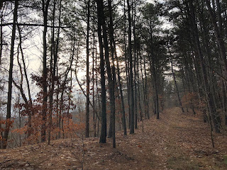
Despite my longstanding disdain for the park, it was such a pleasant place to be in the climate-change January mild chill. The Colt Trail especially passes through some nice scenery with a sense of varying elevations. The views out through the bare trees are not striking or dramatic, but they do give you a sense of a larger world beyond. The panoramas, humble as they are, help to renew your sense of the bigness of the world—and that is a renewal that all of us need from time to time.

The Colt Trail and the perfunctorily-named Short ‘n Sweet Trail form some nice loops just north of Knowlton Road. They’re prettyish, they run along steep drops, and largely follow broad old mining roads. The walk here was everything I’m always looking for in a hike: solitary, silent, meditative, full of new discoveries to delight the eye. I’m not sure that they’d be quite as nice in high summer, when greenery obscures the views, but maybe.

After getting back to my car, parked on Knowlton Road, I got ambitious and decided to look into the oddly named Figure 8 Trail, which runs through the forest on the opposite side of the road. Not exactly a mistake, but it was a bigger venture than I’d expected.

There was some lovely country in there: tall pine forests like these, fragrant and serene. There were a few more views out through the naked trees onto the farmlands below. Billowy groves of evergreen saplings run like hedges along the trail in many places, giving the otherwise gray light of day a green and lively hue. Of course, this being Hillman, the trail also passed through ugly blow downs, where you have to climb carefully among fallen limbs, and big swaths of wasteland where the forest had been strangled by ugly vines.
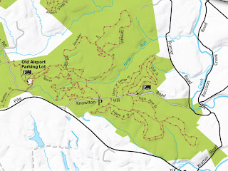
Here’s a map of just the southeastern segment of the park—which is the smallest portion. (Click to enlarge this and any photo.) In the extreme southeastern corner you can see the so-called Figure 8 Trail. I should have known by the name that this trail would have some potential for misdirection, but without a map I was unprepared for just how senseless and convoluted this “figure 8” would be. I assumed a central axis someplace where the trail would cross itself, joining two loops. That would have made sense, right? But alas. Who draws an 8 like this? Who knew that this figure 8 would have an inner loop and an outer loop on its western side and a variety of smaller trails crossing the larger one, creating unexpected junctures to imitate the one you’re looking for? Now that there are maps of Hillman online, it would be wise always to have one with you when you venture to that place. I ended up repeating the eastern loop twice and frantically searching for a connector trail to lead back to the road. All in all, a good day in the woods though. It’ll be nice to have some real winter in the near future. Let’s hope.
No comments:
Post a Comment