Wednesday, November 3, 2021

Grindle Ridge and Pritts Distillery Road

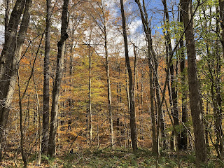
There's a nice view from the Laurel Highlands Hiking Trail as it passes through the Seven Springs Resort.  This shot is taken from the trail about half a mile north of Pritts Distillery Road, which has the most wonderful name of any road, and which is little more than a trail itself--narrow, muddy, a little treacherous.
Of course, in the Laurel Highlands, the woodlands are so dense that you almost need a pipeline swath or electrical easement to get any kind of view out over the lovely hills beyond.  Here's a view from Pritts Distillery Road as it ascends the mountainside and approaches the summit where, unbeknownst to me, the famous resort sat perched in all its great glory.
I did find a nice little acre for sale right on Pritts Distillery Road, and I told myself I'd pay almost any sum to own a piece of property with an address like that: "Pritts Distillery Road."  The owner had put up a sign with her phone number and, frankly, it looked like the sign had been there quite a good long while.  I gave her a call when I got back to Pittsburgh, but she wanted too much for such a steeply sloped property with water and electric but no sewer.
I looked on a map to see where the Laurel Highlands Trail crosses the terrifically named road.  The trail does not announce itself except for the yellow bands of paint that mark the trees just where it crosses over the unpaved track.  This is standard form for the LHHT--it only announces itself at designated parking areas.  Otherwise, you have to look for the yellow bands around the trees where it crosses a road.  If you follow the trail half a mile north from its crossing, you'll travel entirely on Seven Springs property and come to this monstrosity--a ski lift.
There's something strangely Scooby Doo about a ski resort in the off-season.  But it did open up some impressive views out over the Laurel Highlands.
I know people who love this place as a skiing destination.  It's apparently got many trails down the mountainsides; this is only one of dozens.
Which is not to say that Seven Springs sleeps until the snow flies.  It's an active place year-round, with condos and restaurants and I don't know what else.  They kindly allow the LHHT to pass on their property, and they even offer potable drinking water right along the trail.
But!! But...they also have an extremely NOISY shooting range, which is active year-round, and the southbound trail passes uncomfortably close to it.  Before you discover that it's a clay-pigeon shooting area, you hear the endless gunshots from afar and wonder if it's just a whole lot of really trigger-happy hunters in the woods.  Truly, it sounds like a Gettysburg reenactment, and it can be a little intimidating.
I went both directions on the LHHT at Pritts Distillery Road: north to see the view and south to visit the Grindle Ridge shelter area--where my friend and I were supposed to stay for our second night on the trail.  And I gotta say, Grindle Ridge was nice.  It's actually on a ridge with a visual sense of the land falling away through the trees.
Click on this photo to enlarge it; that's ICE on a log at Grindle Ridge.  Ice....
I did the most childish thing.  I saw pretty leaves on the ground and I told myself, "I'll just take one to use as a bookmark."  Of course, when you decide to choose ONE solitary leaf from the autumnal forest floor, it really slows you down because you're forever finding one you like better than the one you already chose.  It was an exercise in stupidity.
Ah, but the leafage was lovely.  
And here is the shelter we reserved but did not use.  It's got its back to the world and sits facing the steep drop out into the valley below.  This would have been a very nice place to spend a night, but it will still be there in the future, I hope.  We did enjoy the spot we had, especially with its excess of firewood.  The spot where we ended up staying two nights was noisy with traffic sounds; this spot sounded like it was in the path of an invading army--with the shooting range so nearby.  But both become quiet at night, I'm sure.  
I do wish I could find an affordable plot of land down here!  It's only an hour and a half away from town.  It's so very beautiful and so much cooler than down in the city.  This is not a lofty elevation, just about 2,700 feet, but it does make a noticeable difference.  And what could be the story behind that name, "Pritts Distillery Road"?  It's got to be a vestige of Prohibition and mountain life.

Tuesday, November 2, 2021

Two Nights on the Laurel Highlands Trail

Fall is here at last...visiting like a ghost in its transient, autumnal way.  It'll be gone in no time. We've endured the dullest, ugliest, hottest, most summerlike October I've ever experienced--aside from the Africa years.  I wanted to enjoy the belated autumn as much as possible, so a friend and I decided to do a quick two-night trek on the Laurel Highlands Trail.  
Work has been stressful.  The endless heatwave summer has been frustrating.  The woods beckoned.  We stayed at the shelter area close to PA Route 31 for a rainy Thursday and Friday night.  October is one of the busy seasons for the trail, but no one else was willing to brave the wet weather, so we had the small, primitive campground to ourselves.
Actually, the reason we chose the Laurel Highlands Trail--despite my blogging a lot about it recently--is because it was going to be chilly and wet, and our tents would have provided too little shelter from the weather.  But the LHHT has Adirondack shelters with fireplaces!  
The remote shelter # 5 was perfect.  We saw not another soul on the trails in the two days of damp hiking that we enjoyed.  A ranger did come by the first night to see that no one was squatting in any of the cozy shelters.  I saw his headlights through the gathering gloom and went down to meet him at his white forest service pickup.  As soon as he got out he called my name and told me that the whole park, which stretches 70 miles from the Johnstown area to Ohiopyle, had only 5 registered campers that night.
Yes, you do have to reserve these shelters online.  And you're not [technically] allowed to stay two consecutive nights in any one camping area....  Isn't this a beautiful setup?  The first night was windy, and there are large openings on either side of the chimney.  Fortunately, my friend thought to bring a tarp to close the gap on one side, and he found an old, singed tarp in the garbage bin that we used to close up the other side at night.  
The colors were so lovely and bright, with intermittent moments of sun and lots of clouds and rain.  But not so much rain that we couldn't put on our raincoats and hit the trails.
The LHHT and environs are beautiful, but I must say, if you're looking for silence, pick a more remote trail!  From many of the shelter areas on this trail, you can hear trucks, and cars, and construction vehicles from early morning and into the night.  There are better trails in the state for silence and solitude, but let's just be honest...life in the Keystone State is LOUD.
The Roaring Run Natural Area was scenic if unexceptional.  And one noise I did not hear was a roaring "run"--which means "arroyo" in most places, but which means "stream" in parts of PA, WV, and OH.
It's the silence that I love the most--maybe even more than the beauty of the forest, I come here for silence.  The best thing about Roaring Run is that at a certain point you do get out of earshot from all the clamorous traffic.  Its ugly screams and drones are silenced, and all you hear is the gentle breeze.
I used to take a volume of A.E. Housman into the woods with me in October to memorize a different poem or two each fall.  I haven't done that for a few years, and so I find myself mentally revisiting the poems I memorized in years past.  It's one of those things where I tell myself that it's just what I do:  "I memorize Housman in the fall.  It speaks to my natural melancholia."  But if I go without doing it for two pandemic falls, will it still be a tradition by the time the leaves turn yellow for the third turn since the pandemic struck?  We're losing so much...and not even noticing what we've lost because we promise ourselves that we'll get back around to it next year.  But I fear that we will not.  
What will life be if this pandemic ends, if the selfish, shortsighted θ-damned Republicans ever deem to get vaccinated and stop visiting new variants on the world?  Bigger picture, come to me!  God, let me see the bigger picture out onto history, and life, and the living world!  There were few real vistas in the area we visited.  I wanted to take my friend to see one or two of them, but time didn't allow.
One of my joys, as I walked through the woods, was simply to look at the leaf-mess on the ground.  So colorful, such vivid tints and tones, so easy to miss.
It's been about 10 years since I'd been back to the Roaring Run Natural Area--where no camping is allowed and where interesting trees try (a little unsuccessfully) to make up for the absence of long views.
You can almost see a bit of a vista through these trees.  The hillside opposite is bedecked in its fading rusty hues.
The beeches still clung to their brilliant yellows and their rapidly fading greens--now so yellowed as to be more acid-green than forest-green.
I know it's a lot to ask, but why can't I just have the month of October off--the way French people all take the whole month of August?  Of course, this climate change October was the worst, and I imagine November will be the new October moving forward.  But this is what I love, what I need--trees still in leaf, bidding their glorious farewells to the summer, casting their earthy scents out into the chilly air, creating an inimitable living tableau for the eyes!  There's not a stained glass cathedral in all of France that can match the beauties of October (or maybe soon, November) in a Pennsylvania woodlot.

Wednesday, October 6, 2021

Laurel Highlands Trail at Kings Mountain Road


It wasn't easy to find the Laurel Highlands Hiking Trail at the high place where Kings Mountain Road peters out into a muddy ATV track.  But the search was scenic and fun.  Oh, the beautiful summer homes up here near the ridge of Laurel Hill!  I just want one so bad...


I got sidetracked by a pleasant snowmobile trail that was nice enough, but not a hiking trail.  A snowmobile trail is built for vehicles, and so it's a small road, not a footpath.  It doesn't seem to penetrate the strange, shady depths of the forest in the same way.  


The road up the mountain was narrow and lovely in the October light.  I did at last find the LHHT but following it further than I'd have expected.  See the stone steps in the lower right corner of this photo.  That's the LHHT.


The golden ferns, the yellowing and browning beech leaves, the golding, and redding, and oranging trees across wide meadows, the glowering and grayling skies.  It was a beautiful day to be alone in the woods at the top of Laurel Ridge.


Again, the map showed a scenic overlook--or at least something photographable--just a short distance from Kings Mountain Road, between mile markers 21 and 22.  And so, I went a-looking for it.  I wish my cell camera, or any camera, could capture the great beauty of this spot in the forest, which is no overlook but truly memorable.  See the strangely majestic beech tree a little to the left and the broad rock floor?  


Here's that same majestic beech from another angle, still insufficient to capture its power and stateliness.  


It looks almost African.


Sometimes I wonder if I shouldn't invest in a decent camera.  If I did, I'd be able to capture the grandeur and perfection of this ancient beech.  I'd also be able to publish a coffee table book about country churches in Western Pennsylvania.


So, just beneath that wondrous tree, there's a rock ledge that overlooks the forest floor below.  See here.  It's got a nice boulder sitting out at the edge to tempt photos and picnics.  I fell into both traps.


It's not an enormous drop to the forest floor below, 20 feet?  But when the leaves are off, there might be a nice view to the hills beyond.


Blue Hole and Cole Run Falls, Forbes State Forest


I'd always heard about "Blue Hole" and thought it sounded like a kind of magical place.  Long ago I even tried to get there once and failed.  But one of the reasons I love maps is because I happened to notice on my old-fashioned paper map that my trek on the Laurel Highlands Hiking Trail near Kings Mountain Road was very close to the mysterious Blue Hole area of the Forbes State Forest.


It's a beautiful drive out to Blue Hole, a long, long descent into down from the summit of Laurel Ridge to the forest valleys on the flanks of that long hill.  Blue Hole itself is a nicely maintained area with an information kiosk, mowed grass, and a few places to park.  And this!  This is Blue Hole.  I think people must swim here when the water levels are higher.


And strangely, the water is in fact BLUE!  Look at it.  Turquoise?  Azure?  Why is it so blue with no sky to reflect?


The roads in this part of the Forbes are so lovely and serene.  From Blue Hole I decided to go looking for the nearby Cole Run Falls.


Again, the water levels aren't very high right now, so this waterfall might be more impressive in May than October.  But the well-marked waterfall is just off the road, and it's impressive enough.  It tumbles maybe 15 feet from above.


Actually, it's a series of small waterfalls, but I really only explored the area closest to the road.  


It's not the waterfalls of Maui, but it was a sweet spot in the woods.


1970?  These trees and I are the same venerable age.