
The Mid-State Trail runs from Maryland to New York, and it passes 325 miles through some of the most scenic areas in Pennsylvania, right up the center of the state.

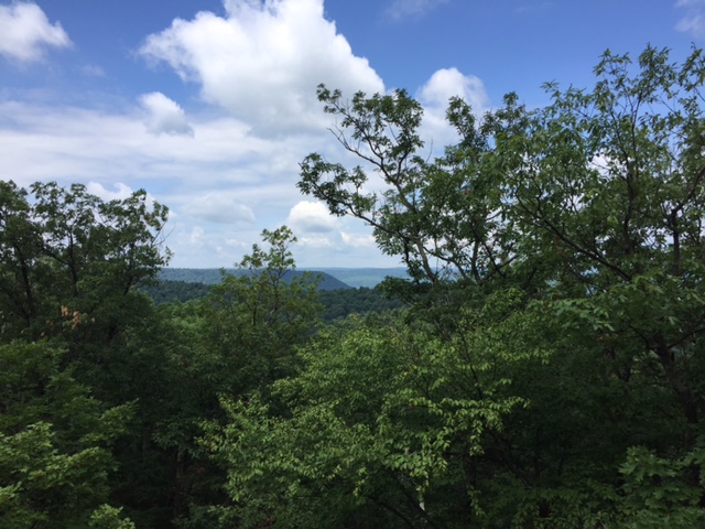
When I arrived at the Buchanan State Forest, the Mid-State trailhead was a little hard to find, and the map seemed to indicate that the trek would be more scenic if I followed the trail north and out of the state forest. It runs along top of the sharp summit of Tussey Mountain, and I expected views on both sides. You can see how the land falls away in both directions in this photo, though views through the trees were rare at first.

It's a pleasant grassy area up there, with nice breezes sweeping the mountaintop and lots of moss on the trail. As you enter the upland meadows of State Game Land #97, you catch little glimpses of the valleys both to the east and to the west of the mountain that you're standing on, but no grand vistas. This is looking east through a small break in the trees.

On the map, it looked like the trail headed this direction would command vast panoramas out over the Ridge and Valley Region--so named because that's exactly what it is: long, low wooded ridges separate long, narrow farming valleys. It's actually a beautiful area with quaint hamlets, enormous farmhouses, and stately, well-maintained barns. You can't see much of it through the trees, though. Again, this photo looks east.
Here's a shot looking west, toward the Laurel Highlands.

The further north I traveled, the better the views, especially to the east. I thought about setting up my hammock at the summit's edge with a view like this to lull me to sleep.

With only a limited time to hike, heading north out of the Buchanan State Forest was definitely the best choice. I also did a few miles southward, into the Buchanan, and the scenery was nice but not nearly as dramatic.

The Mid-State Trail is beautifully blazed. These orange blazes appear at regular intervals, and they're fresh and visible. It's a good thing, too, because in many places the trail is completely overgrown with blackberry thickets and saplings. I beat a path through a lot of the underbrush, all the while thinking about all the ticks and snakes that could be hiding in there.

Oh, and there's just enough poison ivy up here on the mountain's peak to keep things interesting. It's actually a pretty rugged hike, what with the many rocks, and weeds, and thorns crowding out the trail. Whacking at the underbrush to make the trail passable really slowed my trek. But by late morning, I began to see broader and broader views spreading out in the valley to my right.

And then at last, this beautiful overlook! The trail becomes a narrow highland meadow of broken rocks, where no trees can grow. This affords a clear view out to the east--where more state forestland and state game lands are in view. See how the clouds cast shadows over the lower hills and the meadows in the valley below. This is a truly lovely spot.

Here you can see a bit of the boulder field. The path runs straight ahead, directly over the tops of the rocks. Hikers say that the Mid-State is the wildest trail in the state, and I don't doubt it--though "wild" may just be a code word for "neglected," and many backpacking trails here seem to be thoroughly neglected. Who can you blame? These trails are maintained by volunteers; that's 325 miles of jaggers, and nettles, and brambles, and blackberry bushes to keep down. I hung out here on the rocks until I decided to continue the slow march to the north.

I was stopped short by this guy. Click on the photo to enlarge it. Honestly, I'm not really all that scared of snakes, but you know the cold chills you sometimes get when you see one lurking in a spot where you were just about to place your foot? I got those chills when I saw this guy, and I remained chilled for the next five or six minutes. He was big, much thicker than a garden hose. And the way he just lay there in the path gave me pause. How many more of these fellas are all around me in these sunny rocks, just waiting to make themselves known?

Since coming back to Pittsburgh and doing more research on the Mid-State, I've found that this view is relatively mild compared to many others that the trail offers. There are actually people who do "through hikes" on this path, just like on the Appalachian Trail or the Laurel Highlands Hiking Trail. And yet, this trail seems to stick almost entirely to the very crests of long ridgelines and even stays atop the long, rocky summit of Tussey Mountain for many miles...so where do backpackers find water?

Apparently Massachusetts also has a Mid-State Trail--and the scenery isn't unlike this. I'll admit to being just a little bit disappointed with the state of the trail. All the thorn bushes and poison ivy made for a slow hike. The thought of doing it with forty pounds on my back and timber rattlers underfoot is pretty daunting. The Mid-State is being billed as part of the "Great Eastern Trail," a more remote, more scenic alternative to the overcrowded Appalachian Trail. Maybe when the Great Eastern Trail really catches on, the Mid-State will become better established due to increased (but not over-increased) foot traffic. The website for the Great Eastern Trail calls the Mid-State its "western loop" in Pennsylvania, and it has describes the Mid-State a little ominously:
The longest and wildest of Pennsylvania’s footpaths where if you hike alone, you will still meet more bears than people. Sharp boulders, knife-edge rocks, forever views, and little water greet intrepid hikers who take on the west loop.
No comments:
Post a Comment