
Saturday, May 14, 2022

Friday, May 13, 2022
Sinking Valley and the Elusive Summit of Brush Mountain

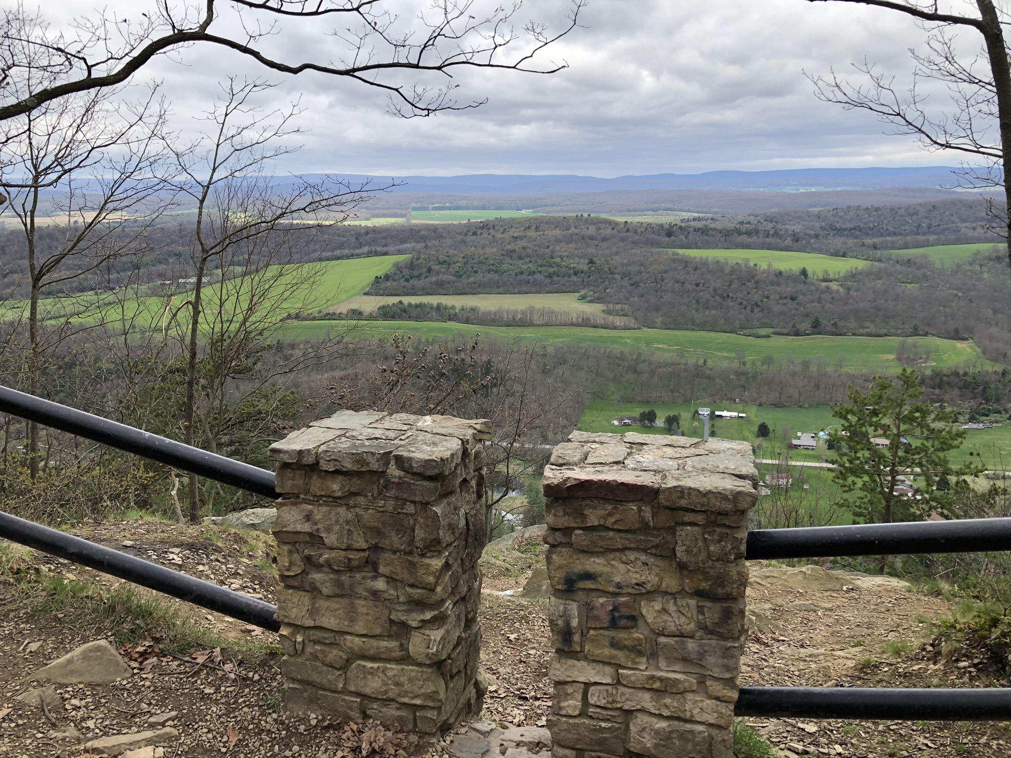
This is Sinking Valley--an upland hollow of farms and meadows that stands in the miles-wide maw of Brush Mountain. Hmm, that sentence wasn't very clear... The valley stands in a weird dip where the selfsame hill makes a broad zigzag that looks, on a map, like a dragon with its mouth open to swallow the farmland between its teeth. When the villainous Brush Mountain again defeated my attempts to reach its summit, I consoled myself with exploring Sinking Valley by car.

I had arrived at the little lane that leads up to the western tract of State Game Land 166 at 10:30am, ready to summit the elusive stony peak that overlooks Altoona. But the little road was blocked by utility vehicles which remained there the rest of the day. What they were doing, I don't know. Trimming branches, working on the power lines? All I saw them doing was standing around blocking the road that I needed to take. A local guy eyed me suspiciously, a gruff old mountain man who looked about 65 but was probably close to my age. He looked at my two trekking poles, my pantlegs tucked into my socks (against ticks), my REI gear. He gestured at the sharp-tipped poles and said, "You snake huntin'?" I explained that I was trying to get to the summit of Brush Mountain. We talked for a while, and he discouraged my plans. "The trail's too steep up them rocks, and they'll be crawling with snakes."

Actually, I would have done it anyway, except that he redirected me to the route I'd taken last week, and he assured me that the little lane I traveled last time would wind around to a broad overlook to the east, if I just follow it far enough. And since I hadn't wanted to hike the whole way from the main road to the summit anyway, I returned to the same trek I did last week with the intention of following it all the way to an overlook.... There was no overlook. The trail ended at a No Trespassing sign. So I came back down and drove around the valley. This is Fort Roberdeau, a Revolutionary War fort that was built to protect the lead mines where the Continental Army got lead for its musket balls. It never saw a battle and was only operational for two years. Still, it's cool that the Revolutionary War reached the whole way into these mountains. The place was crawling with school children, so I didn't take a tour.

And here's Sinking Valley Presbyterian Church, founded in 1790. It sits in a scenic spot near a stream and surrounded by its peaceful cemetery. It's not sectarian bias that causes me to document so many Presbyterian churches on this site. It's just that the Scottish and Scotch-Irish Presbyterians tended to be the first white settlers into the Pennsylvania interior, and for that reason, many old rural churches belong to that denominational franchise.

After being turned back once again by the mountain (strike two!), I tried to enter the big eastern tract of State Game Land 166 by way of Canoe Creek State Park. That, too, was what the kids call and "epic fail." Instead of a bucolic wildlife reserve and hunting park, I ended up in a place called Scotch Valley, where I found miles and miles of beautifully tended farms, vast green lawns with long tree-lined driveways leading to immense and palatial homes, most of which appear to have been built in the last 20 years. There was a beautiful country club and miles and miles of landscaping. No disrespect to Altoona, but I didn't expect to find such a wealthy little valley hidden away there. I mean, "Altoona Style Pizza" doesn't exactly inspire confidence....

In a letter to George Washington in the 1770s, one General Roberdeaux writes that he has established a fort at the foot of "Tussee Mountain" to protect the lead works used for the manufacture of ammunition. I could see how Tussey Mountain and Brush Mountain sort of run together. He calls the place "Sinking Spring Valley," which makes a little more sense than "Sinking Valley." The cemetery at the church was worth a visit.

Although I hated to trek again in the exact same woodlands as last week, they were indeed beautiful in the bright sunlight--though they were beautiful too beneath glowering skies. They're called "gallery forests," where the trees stand like pillars with almost no understory or brush to conceal the forest floor. I've got one last plan to make it to the summit of Brush Mountain, but it might be a longshot. If I fail on the third attempt I'll consider myself struck out.
Saturday, May 7, 2022
Brush Mountain and State Game Land 166

If you've ever driven I-99--which is a north / south interstate that runs along the eastern edges of Altoona--you've surely seen the stony-topped mountain that looms darkly over the roadway and the town. This is it, Brush Mountain, and I went back to Central Pennsylvania again to see if I couldn't summit this humble peak. I was hoping to reach the barren stretches near the top of the mountain so that I could look out over Altoona and the surrounding countryside.

All the easy ways up the mountain are on private land and marked with No Trespassing signs. On a map, I located an ascent that was entirely within the bounds of State Game Land 166. All of our state game lands are open to hiking, just not camping. I drove across Brush Mountain, where Kettle Road runs through a high mountain pass, in order to begin my climb back up to the summit from Sinking Valley, which is a hollow that sits on the far side of the ridge. This valley stands between two separate arms of the mountain, and it contains an old Revolutionary War fort that protected the mines from which colonists drew lead for the manufacture of their ammunition. I saw a sign for the state game lands on the wrong side of the road but thought I must have missed my intended ascent. So I allowed myself to get sidetracked by this mossy old road (open only to horses, bikes, and feet) that climbed ever upward on the wrong arm of the mountain--which splits like a snake tongue. I was hoping at least to reach a summit--if not the one I'd originally intended.

The views were not as remarkable as they've been of late. I caught some nice glimpses of the farmland below through trees just beginning to take on leaves in delicate, almost-pastel colors. In a few weeks, the leaves will obscure what little view there is.

The manic-depressive skies were, by turns, glowering and bright. The flanks of the more easterly head of Brush Mountain were pleasant, but I found no clear track leading to the summit, just a road that went up high and then petered out into a narrow path that began to descend on the same side of the hill. Also, aerial photos on Google showed no clear rocky patches where trees would not obstruct the view even if I could reach the summit on this part of the mountain.

I had an elderly parishioner back in Kane who had married a fellow from that town and moved there from Vermont as a young woman. She had the most wonderful old-timey Vermont accent. She also had a real crabapple tree in her front yard--as opposed to these ornamental ones, which have poison apples. She invited us to come and pick some crabapples to make wine--which turned out so delicious! When we showed up, she was blaring "Appalachian Spring" by Aaron Copeland at a surprising volume. I mean, loud enough for the neighbors to call the police--on an old woman playing Copeland. "Appalachian Spring" is a 1944 ballet, and ballet is not my thing. But it's set in the mountains of Central Pennsylvania, and its reinterpretation of the familiar old American hymn tune "Simple Gifts" is really beautiful.

I thought of her and of that day as I walked the Appalachians of Central Pennsylvania "robed in the blooming garb of spring." What a beautiful time to be in the hills and forests. And though my weekly adventure may have been considered a failure in that I did not get to summit Brush Mountain, as I drove toward home--still in Sinking Valley--I did find the game lands on the correct side of the mountain and the upward path that I'm sure will lead me to the vistas I'm looking for. That will be an adventure for another day....

I'd read online that hang-gliders use Brush Mountain to push off from, but I don't know where they would do that. The areas that are not privately owned are under the jurisdiction of the PA Game Commission--and not easily accessible. See on this game lands map how Brush Mountain zigzags? The yellowish areas are public lands, and the smaller yellow segment to the left (west) is where I need to be. But that big area to the east surely holds some hidden wonders. There's a whole stream valley in there, a so-called "hollow." O the beauty of being able-bodied and curious!
Thursday, April 28, 2022
Tussey Mountain, Rothrock State Forest

This is Tussey Mountain as seen from afar. It sure looks smaller from this distance than it feels from up-close. Wikipedia has a much more convincing photo.

My interest in climbing Tussey Mountain was due to the fact that I'd been hearing the name for many years, and I wanted to add it to the list of "peaks" I'd documented on a certain peak-baggers' website--with photos. While I was up there, I also wanted to take a photo of Stone Mountain. I had already claimed Stone Mountain on the peak baggers' site and wanted to add a photo of the peak from afar. I'm the first person on the site to claim Stone Mountain, making me "King of the Mountain" for that low ridge of 2,190 feet--with 560 feet prominence. Apparently a mountain's "prominence" is the distance that it rises above the surrounding countryside.

See here, even the trees of Central Pennsylvania are praying for Ukraine. Honestly, I've done much higher and more taxing climbs on mountainsides in Colorado and arrived at far more stunning views. But because those climbs did not take me to any "peaks," these lesser ascents are claimable and the higher ones out west are not. You can even claim having "ascended" the high point for the state of Delaware--a mere hill of 447 feet--and that counts. However, climbing 3,000 feet to a waterfall overlooking Vail does not because it's not at the top of the mountain. Real mountain climbers must resent us Easterners claiming 2,100 foot hills as "mountains" that we've "summitted."

I was mistaken if I expected a clear view of Stone Mountain from the summit of Tussey Mountain. There's a freestanding mountain called Round Top that obscures the view. See them here: Round Top in the foreground and Stone Mountain at the horizon.

About halfway up Tussey Mountain on the Yellow Trail, you come across a place known as "Indian Overlook." It looks out across farmland to the north and west.
I thought these views were spectacular and assumed that I must be almost at the crest of the rocky mountain.

But no. The westward view from Indian Overlook is actually not that high and not that great.... After the overlook, you pass through a wooded plateau before beginning the last climb toward the actual crest. There's a slippery rock scramble toward the actual summit of Tussey Mountain--steep and slippery with rocks the size of large gravel.

But then you reach the crest of the mountain, and here you are. If you come anytime between November and April, you'll find the branches bare, which makes the view so much better. I imagine it's a "green tunnel" in high summer, with the occasional opening among the green boughs. See in this photo how the countryside falls away to either side of the peak.

This is the Mid State Trail, where ridge-walking is a way of life...at least for a few weeks. There's little water up here on the heights, and the wind blows hard.

But the views are lovely. This is a shot from the summit of Tussey Mountain near Colerain Road, looking northwest into farmland.

This is looking east from the same trail. There are so many more mountains off this direction. The ridge in the middle distance, right on the horizon where the land meets the sky, is Stone Mountain, which a friend and I explored in a snowstorm last week, and of which (did I mention?) I'm king.

Here again is Stone Mountain--my regal domain. But how can you look away from its ephemeral beauty, its delicate charms--distant, unapproachable, veiled in blue mists, older than all knowing? These peaks were once as high as the Rockies, but they've eroded over vast eons of time. These are said to be some of the most ancient mountains on earth.

Here's a view looking the opposite direction--west and south.

This interestingly shaped feature is called Brush Mountain. It looms, doesn't it? I gotta say, I don't love the utilitarian, unimaginative names of these hills.

Instead of taking the steep and rock-strewn trail back to the bottom, I followed a forest road--just because long, rocky downhill treks are hard on an old guy's knees.

There's a camping area with two picnic tables a little more than halfway down the mountain, and approachable by car. Here's the view from there. It was a beautiful day on Tussey Mountain. I was looking forward to claiming the ascent on the peak-baggers' site, but found that although many peaks on Tussey Mountain are named and mapped, this one is not. Round Top is on there--and no one has claimed it yet, meaning that I could be "king" of that mountain, too. But even though the ridge I reached on foot was a little taller than Round Top, I hesitate to place a misleading claim. There is a path to the top of Round Top, so I could come back and claim it aright. But the three-hour drive each direction was wearisome, as was the chore of crossing Pittsburgh in evening rush hour traffic. All in all, a nice day on the chilly heights of Tussey Mountain.
Sunday, April 24, 2022
Kayaking from Bridgeville to Carnegie on Chartiers Creek
Well...not starting out in Bridgeville proper. There's a waterfall right beside the old Woodville House (1775), and it's just a little to high to go over in a kayak. I did see a video online long ago of people going over it in canoes, but I wasn't feeling that adventurous. I've been told that the creek divides and there's an alternate route which bypasses the waterfall on the east side of Washington Pike, but I haven't scoped it out. So I put in behind the giant office park across the road from Woodville House. The water levels were perfect--relatively deep in many places. I only bottomed out two or three times and only had to get out of the boat to pull it off the rocks once--and that was because I chose the wrong course. It would have been possible to paddle the whole distance without ever getting out to pull your boat off the rocks, which is unusual for a trip down Chartiers Creek.

It was beautiful to be on the water today! There were fish jumping and wild ducks and hordes of Canada geese. Birds were singing and redbuds and magnolias were blooming. Since the creation of Uber, now I can just leave my kayak under the Mansfield Avenue Bridge in Carnegie, Uber back to my car and then drive in and pick up the kayak. It totally revolutionizes kayaking for me. When my Uber came, I left my kayak in the care of two teenage kids who were under the bridge *smoking.* I told them they could paddle around in it till I got back in my car. Nice kids, though in hindsight I might have put them at risk by allowing them to play around in my kayak for half an hour. Neither of them had ever kayaked before, I didn't have a lifejacket on board, and they were pretty spaced out...
Tuesday, April 19, 2022
“We Think We’re Goin’ 8…Maybe 7”
A short video shot at the Stone Mountain Hawk Watch just before the April snowstorm rolled over us. (We ended up going 7: three and a half triumphant miles northward and the same shame-filled distance back….)
An April Blizzard in the Rothrock State Forest

The weather report for Belleville, Pennsylvania--the village at the foot of Stone Mountain--called for snow flurries mixed with rain and chilly (but not unbearable) temps on Easter Monday and Tuesday. I'd had this trek on the Standing Stone Trail planned for weeks. I needed it, and I wasn't about to let a late, lingering winter keep me from it. When my friend and I got to the trailhead at Allensville Mountain Road, this was how things looked.

Although a Democrat, my friend is a Texan through and through. He lives in Pittsburgh proper and can barely bring himself to say a single positive word about any place that is not the Lone Star State. He even thinks that the big decorative stars that people put on the outside walls of their houses mean that they wish they lived in Texas. He and I have backpacked Big Bend together as well as Dolly Sods and a few places in Northern Pennsylvania. He might grudgingly enjoy the treks, but he'll never admit to liking any destination outside of Texas--with the sole exception of the Sods. "It's too wet here." "There are too many trees." "Where are the armadillos?"

But when it comes to choosing a hiking destination, he's utterly passive. He lets me do all the planning. And so I decided to take him to an undeniably beautiful part of the state that he so despises. The forecast was concerning, but even after an hour on the trail, the wintry weather showed no signs of materializing. We were going to hike 9 miles or so north from the trailhead on Allensville Mountain Road to a campsite I had reserved in the campground at Greenwood Furnace State Park. There are at least seven really gorgeous overlooks along that mountaintop hike. I'd scheduled a rural taxi service to shuttle us back to the car in the morning, and then we were going to drive half an hour south to Jacks Mountain, where we intended to hike up to those parts of the Standing Stone Trail known as the Throne Room and the Hall of the Mountain King.

We broke for lunch at the overlook known as the "Little Vista." It's one of the few views off to the western side of the mountain--which is admittedly less dramatic than the eastward views. It's still pretty. As we sat there, we saw mists soaring rapidly up the valley from the south. Tiny snow flurries appeared all around us, and we observed, "Huh, maybe we'll get a little snow after all." Here are the mists rolling in from the south and west at the Little Vista. They looked so harmless at first...

We thought little of it and continued our northward trek toward Greenwood Furnace. Temps began to drop fast. The wind picked up, blowing hard from the east--which is odd--and the flurries turned into a blinding whiteout. We reached a sign telling us that Greenwood Furnace was still another six miles away, and at that point we turned around and headed back to the car. The pleasant hike on the ridge of the humble Stone Mountain had begun to feel like one of those documentaries about climbers who perish in the snows while attempting to climb Mt. Everest. When we had crossed Saussers Stone Pile on the northerly march, it was entirely dry. On the southward return trudge through the snow, it looked like this.

The actual height of Stone Mountain is 2,190 feet; the so-called "prominence" is 560 feet. The wind blew the snow hard and fast up on the stony heights. The spectacular views disappeared entirely. The mountaintop was socked in by endless flying snow. My beard iced over! The rocks became treacherous and slippery. When we finally made it back to the car, it was covered in snow. We had walked 7 miles in three and a half hours on rugged terrain and in bad weather conditions--3.5 miles each way. Not bad, really. The narrow, winding road up the mountain has steep drops and no guardrails--spooky enough in clear weather and borderline harrowing under these conditions. I thought we'd get down off the mountain to find that springtime still held some command of the world below. Maybe we could even drive to the state park and claim our campsite. I was wrong. Winter had returned with a wicked vengeance. Amish buggies trotted along the slushy roads. An Amish boy pulled his little brother in a sled, enjoying the return of the snow--both of them still wearing the straw hats that Amish men exchange for their wool hats in April. Driving was tricky and slow most of the way back to Pittsburgh. I won't lie; it was a big disappointment. I really needed a night in the woods. April snow always reminds me of that depressing line in the old Barbara Streisand song that was popular when I was little: "...like a rose under the April snow..." I like winter. I like snow. But after Easter? And yet...my friend did admit that he liked the views from up there on the Standing Stone Trail.
Subscribe to:
Posts (Atom)