Tuesday, January 29, 2013
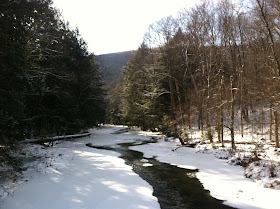
South Branch Kinzua Creek, Allegheny National Forest
Kinzua Creek lends its name to several things in this region: a reservoir, a famous bridge, a few streets. The "A" at the end of the word isn't pronounced; locals call it KIN-zoo. If you call it kin-ZOO-ah, you'll get yourself branded as a come-from-away. But hell, they'll know just by your car, and your hat, and your backpack that you're not from these parts. General Thomas Kane recruited a lot of Swedes to settle this part of the state because he thought they would tolerate the climate better than other Europeans. They're goodhearted people up in this area, but they're not very effervescent or forthcoming with strangers. Truly, with the gray skies and silent people, you could sometimes think you were on the set of a Bergman movie...
Kinzua is a storied stream. It flows past the rustic old Inn (with a top notch restaurant) at Westline and through some of the loveliest parts of the forest. The word Kinzua evokes a sense of wilderness, beauty, and adventure in the minds of many folks in Western Pennsylvania and upstate New York. It's our minor equivalent to the words Yellowstone or Yosemite. In fact, until a rare tornado took out the famous Kinzua Railroad Bridge, there was a train from Kane out to the Kinzua gorge, with all the attendant B&Bs and tourism. Most of the tourism is gone now, though motorcyclists still like to roll down US 6. When I was living in West Africa--five years of endless summer--some family members took an October trip on the Kinzua train and sent photos to me. Those pictures set my heart to yearning for home.
My third and final day in the forest required me to trek in an area relatively close to the cabin we were renting, because my wife needed the car. Since we were staying in the little hamlet aptly known as "Blissville," it only made sense to explore the South Branch of the fabled Kinzua Creek. In all honesty, I would have bushwhacked along the main branch of the creek if I had been able to cross over to it, but neither the big bridge on PA 321 nor the little bridge in this photo appealed to me. This region has a special place in my heart. I learned to kayak on the waters pictured here.
I know the rough forest road that goes from this area to the scenic village of Westline by following the north bank of Kinzua Creek, main branch. But I'd always heard that there was a lesser-known passage along the south shore, too. I set out in quest of it and, frankly, never found it. Instead I found a spectacular old logging road that hugs a mountainside and gradually ascends a steep bank above the creek.
I'd estimate that the road dates back to pre-National Forest days--one hundred years or more. It's long since disused, narrow, and in places a little scary to tread in the snow. The drop to the left was long and far into the icy waters of the Kinzua.
The old forest road doesn't appear on any map, and I soon figured out that it wouldn't take me to Westline, which was fine; I didn't have time to go that far anyway. See the stream as it snakes through this photo. The road winds above this ever deepening valley on its way up the hill, and the views get better and better as you go.
In time, the old road breaks away from the stream valley and trails off rightward into a hollow that divides the mountain's ridge into two separate summits. This hollow leads toward a high pass between the two peaks, but this segment of the road is very old and so choked with jaggers that it would be impassable in high summer. The hollow is pictured below. Alas, I didn't have enough time to pick my way through the brambles all the way up to the mountain pass. But I did rest on a boulder and play my panpipes: sad, medieval melodies, echoing out over rock and glen, for all the sylvan world to hear.
If anyone is adventurous enough to make this unknown trek, it wouldn't be too hard to find. Take PA 321 north out of Kane. As you come up on the unincorporated village that locals call Blissville (about seven miles from Kane?), slow down and look for Forest Road # 279 on the right. If you pass Bob's Trading Post, on the left, then you've gone a little too far. There are a few signs at FR 279. One says, "Snowmobile Trail # 1." Another says, "Road closed 500 feet." Follow the road anyway to a parking area on the left. Walk past the gate and toward a snowmobile bridge that crosses the creek, straight ahead. Now comes the tricky part: measure exactly 95 medium-sized paces from the end of the bridge, then turn left into the brush. Keep walking despite the absence of a trail; you'll ford a small brook and continue past an enormous fallen tree on your left. The old logging road will appear in front of you as it begins its long ascent up the mountainside. By far the best trek of this winter pilgrimage....


No comments:
Post a Comment