Thursday, February 29, 2024

Kelly Hill, Allegheny National Forest


I don’t know if the ridge I explored today is named Kelly Hill.  My maps show its modest height at 1,733 feet, but they don’t give the lonely mountain a name.  And yet, the narrow, paved lane that hugs the mountainside and leads up into this area is called Kelly Hill Road, so I’m assuming the road is named for the hill that it leads to.


I’m at my hunting camp to work on some writing projects, and I thought I’d bag the unnamed peak of what is probably Kelly Hill.  My longstanding rule has been only to claim peaks that are higher than 2,000 feet, but the heights are less lofty up here than in the Laurel Highlands, although the trees are far grander and the land is much wilder. Today was true winter—23 degrees for most of my upland trek.  It’s nice to have a real winter day for the Leap Year.  I hiked just short of six miles.


This peak did not appear on the peak-bagging website where I log my climbs, so I submitted it to be added.  I can’t claim it till they approve my submission, so I’m waiting.  It’s so lovely to have a place within easy reach of the the Allegheny National Forest, the woodland that I love.  Actually, my camp is surrounded by woods, but most of the forestland up here belongs to lumber companies, and it’s marked with No Trespassing signs (which I’m going to have to ignore someday).  


Here’s the lonely summit of Kelly Hill.  There are little dirt lanes in this part of the woods leading to oil wells.  The signs at the oil wells say that they are located on Knupp Farm—which must be what this quadrant of the forest is named.  A family named Knupp once worked these rocky highland ridges.  It was surely a hard life.  Instead of Kelly Hill, I thought it would be fun to dub this summit—pictured here—Knupp Knob, pronouncing the K in both words.  The federal government purchased all this land in the 1920s to create a national forest in this place, but it did not buy the mineral rights, so there’s a lot of oil drilling here, except in protected zones.


The teaberries up here on Knupp Knob (or Kelly Hill) are huge, abundant, and flavorful.  Most teaberries barely carry the faintest whiff of mint about them, but these are very minty.  They’re called teaberries because their leaves were used to make an ersatz tea during the British tea embargoes during and after the Revolutionary War.  You have to let the leaves sit in water for a few days, then remove them and heat the water.  It’s drinkable.  Another woodland tea can be made from pine needles. 


Here’s the view from the top.  Once again, there would be nothing but leaves in the summer.  It’s such a joy to be back in the woods of Northern Pennsylvania.  I could begin posting on my old blog again, The Allegheny Journal, which was dedicated to public lands up in this region, and which I had to all-but-abandon when we moved to Pittsburgh, lo these 14 years ago.  When I lived up here, the old blog was actually pretty popular.  I believe it was the only blog dedicated to the Allegheny National Forest...and might still be.  An online travel magazine republished many of its articles.  But that was long ago.  

PS: The peak-bagging site did not approve my submission of Kelly Hill.  Although is’t higher than many a high point in the Midwestern states, they said it did not have a summit.  I’lll have to relish my achievement privately.

Tuesday, February 27, 2024

Memories...and a Link to Utah Photo-Dump

You know, I keep this blog for myself.  I tell certain, select individuals how to find it if I’ve covered something that might be of interest to them, and anyone looking around the internet can find it, too.  But my readership is infinitesimal, and I have no intention of changing that.  I mostly just want a record of my hikes and travels.  And since scrapbooking is not my kind of thing, I blog and call it a “photo-journal.”  But sometimes my various treks raise thoughts that aren’t necessarily in keeping with the nature of the blog, and I give voice to them anyway.  Like this.  Ever since life called me back within the sphere of Oil City, my hometown, I’ve been thinking more and more about the strange old couple there who were known to me as “grandma” and my almost completely unknowable “grandpa.” He came back from Germany after World War II and barely uttered another word until his death.  He headed off to Pennzoil each weekday morning with a lunch bucket and a big thermos of coffee.  The oil refinery made the whole valley smell like fresh bandages back in those days.  It’s a smell I miss.

This was my grandparents’ house.  Actually, it was our house, but my grandparents lived there because my father gave up his true calling as an art teacher and fell into a line of work where housing was provided and frequent relocations were expected.  I took this photo in January of 2020, on the day I turned 50 and my now-dead grandfather would have turned 100.  He was 50 years older than me to the day.  And I was his 7th grandchild—and far from the last.  Can you imagine being a grandfather seven times over by the time you’re 50? The house had been sitting abandoned already for a year or two prior to the photo—but much neglected for long decades prior to being deserted.  Grandma was a mean old woman, about as tall as newell post, and she hated us.  My four siblings and I were sent individually each summer to spend a week with my OTHER grandma (who adored us), so it only seemed fair to my parents that each of us should spend a week with the Oil City grandma too—despite the fact that she did not want us.  During her week playing grandma—of which she had five every summer, mind you—she would always send us off to stay with my aunt, uncle, and cousins in the nearby village of Plumer.  “Kids need to be in the country,” she would say.  What she meant by that was, “Kids need to be where I am not.”  I suppose you can’t blame an old lady for wanting to have her own space.  She had a pet skunk as a child, when she was growing up very near to the place where I just bought a hunting camp.  She used to scrub our faces with a washcloth as if she were scraping barnacles from the hull of a tugboat.  She was a terrible cook, a breathless gossip, and I rarely saw her smile.  If she did get stuck keeping us at her house overnight, she always made us pray on our knees just before bed, kneeling with our elbows on the seat of the couch.  (Bad religion was her family’s banshee.)  Then we’d lie awake and listen to the scary noises in her big, creepy house—a place that I loved to explore.  

But, as happens with many folks, grandma became kinder as she grew older and needier.  By the time I got back from half-a-decade living overseas, she had begun to soften around the edges.  I actually helped her and grandpa move into a retirement high rise because the old house, pictured here, was barely livable.  It hadn’t been painted since the 1970s; the roof leaked; the electrical wiring was a real fire-hazard; the windows were drafty and broken in places; high porches were rotting off the back and sides of the house; squirrels, chipmunks, and mice had made burrows in the walls; the plumbing was a mess.  Worst of all, the only bathroom was on the second floor—where old grandma could no longer venture.  The house sat empty until I, newly repatriated and unsure of myself, decided to live there alone while I tried to get my bearings and get used to being back in America.  I felt a little bit responsible for her and grandpa.  They’d never invested much time or care into me, but they were old and needy and running loose in the world.  Grandpa drove his ancient Dodge Dart the wrong way down a one-way street and got chased a few miles by the police.  He never heard the sirens or saw the flashing lights nor even knew that they were chasing him till he parked at his high rise.  On her deathbed, I told my grandmother I loved her, and she said, “Thanks.”  She was terrified of dying.  She half-believed she was going to wake up in hell for getting divorced (from an abuser) and remarried…back in the 1940s.  Bad religion runs deep, and many people never escape it.  It makes them mean in life and frightened in death.  Faith ought to be a source of comfort and goodwill and hope.  

Now, if you’ve waded through all of my reminiscing about people and places you do not know, then click HERE for a link to my December hiking trip to The Needles District in Canyonlands National Park, Utah.  It was a beautiful place, but not my world.  I belong beneath the shade of hemlocks.  As A.E. Housman says: “Give me a land of boughs in leaf, a land of trees that stand.  Where trees are fallen, there is grief; I love no leafless land…”  

Thursday, February 22, 2024

Anders Run Natural Area, Cornplanter State Forest


I’d heard about the Anders Run Natural Area in the Cornplanter State Forest, but it always seemed too far-flung to bother with…until I came to own property up in that part of the woods.  It’s a small 96-acre area of woodland in the hollow of Anders Run that hasn’t been logged since 1804.  The pine and hemlock forests here are over 200 years old, and some publicity materials suggest that there trees here as old as 400-years.


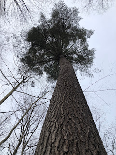
I can’t tell the age of a tree just by looking, but there are indeed some massive specimens on the steep hillsides above the otherwise unremarkable Anders Run.  Evergreen forests are such a luxurious thing, especially in winter.


I propped my cap and walking stick up against this old white pine just to give the photo a sense of scale.  


Some trees in this area had blown down in recent years, and their gargantuan trunks are left to decompose on the forest floor.  I had no interest in photographing fallen trees, but they were fearsomely majestic even in their destruction.


There are really only two miles of trails at Anders Run, with a small public gravel lane running through the middle—which spoils the ancient feeling of the forest here.  But it’s a joy all the same to consort with these ages-old creatures who were alive and growing here since before the War of 1812…and maybe even before the First English Civil War…(1640s).


I accidentally strayed off into private lands and, as is my wont, I headed uphill in hopes of bagging an unclaimed peak on my peak-bagging page.  I later learned that I’d reached the high eastern ridge of a certain Crippen Hill (1,883 ft.), but this is not its true summit, so I can’t claim it.  Still, it was fun to explore.  


Nice views off the Allegheny River.  And by the way, the drive up here from my camp follows the river, and it is so, so beautiful—almost Alaskan in its wildness and strangeness and isolation.


These muddy roads crisscross the hillsides as soon as you leave the evergreen woods of Anders Run.  I don’t know what kind of vehicles travel such roads.


On my way back down, the boundaries between public and private land appeared well enough marked.


Ah, but look at this lonely giant, so splendid in its power and its solitude.  It contentedly passes its years in this one spot, and the world passes by unnoticed and unnoticing.  


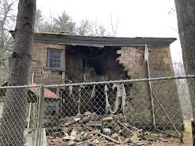
The nearest village is named Irvine in honor of the first landowners who had a large estate here.  This is one of their early homes, built in 1841 and now fallen into ruin and fenced off.  It sits in the woods in the valley of Anders Run.  They apparently built larger houses in the village.


Historical preservation means so little in this state.  Beautiful, historic buildings are forever falling into ruin and being left to rot, even on public lands where you would expect the state to take some responsibility for restoring them as a part of our cultural heritage.  But no.  


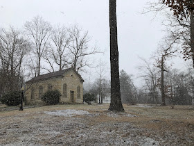
In the nearby village of Irvine, the eponymous founding family constructed the stone Presbyterian church in the exact same style as their home—maybe only slightly fancier, like “Greek Revival,” has nothing to do with the religious “revivals” of that era.  I’ve never been inside, but I think I may have known the “lay pastor” who kept the flock here long ago.  (I did her husband’s funeral, unless maybe I’m thinking of another really cool, historic Presbyterian church at Sugar Grove...The little village churches of that denomination are so old and beautiful up here, and I do judge them by their architecture.)  The church was completed in 1838.  

According to the website warrengives.com:

Dr. William Irvine built the stone structure as a wedding gift for his wife Sarah Duncan.  Sarah was teaching Sunday School on their big porch for the children of their tenant farmers and local Indian children.  She asked for a simple frame structure to use as a Church, but the Doctor had another vision.  He hired an immigrant stonemason from Scotland to build the classic structure.  Unfortunately, the first service in the Church was Sarah’s funeral, hence,  the Church is known to the locals as the Church that Love built.


Monday, February 12, 2024

Venango Villa, or “Lone Pine,” Before & After

So this is a photo of the front room that the real estate agent took when she was trying to sell the place.  
It’s a typical 1970s mobile home with dark wood on the “accent wall” to give the tiny house an air of respectability.  Instead of an overhead light, there are wall sconces to create the same respectable effect.  The sweet old lady who died here did not really care about putting curtains on the windows, though the dark woods all around the place seem menacing when night falls.  She mostly dealt in cheap Venetian blinds and lacy valences.  Garsh, I tore so many dusty old valences out of this place…
Me?  I like curtains, real, light-blocking curtains.  This is not the exact same angle, and the realtor had a better camera than mine, but here’s the front room after a lot of work.  I was going for the whole Pennsylvania German / Scandinavian look.
And here’s the kitchen area of the same front room before we bought it.  Why did anyone think dark stained kitchen cabinets would look good—ever?  
We still want to replace the linoleum flooring, but this is a lot better, right?  The bedrooms and bathroom are better now too, but still not finished.  My wife is up there right now with her gay best friend, trying to write a book about suicide.  If we ever put the place up on Verbo or AirBnB, I think I’ll call it “Lone Pine,” for the single enormous white pine that towers over the house.

Sandy Creek Trail, Venango County


One thing the new hunting camp up north has done is cause me to hike less, ironically.  I’ve just been spending my days off working on the place.  (Actually, I should put up some “before & after” shots of the inside; the change from old 70s trailer to clean Northern chic is pretty dramatic.)  And yet, I did get to hit one trail on my last trip up there, the Sandy Creek Trail.  


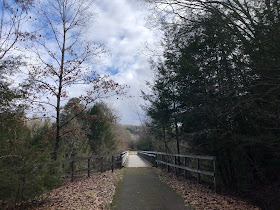
I suspected that the Sandy Creek would be a paved rail trail, and I was right.  But it was still pleasant, isolated, scenic, and solitary.  There was one other car parked at the trailhead, but I saw not a soul out there in about one hour of hiking.  This is Sandy Creek.


Rail trails are considered “multi-use,” but serious hikers tend to avoid them because they’re typically heavily trafficked and overrun with cyclists.  I’m glad my old homeland of Venango County is developing some nice rail trails.  Lord knows there were a lot of railroads sitting empty up there.  But I have an ambivalence toward rail trails.  Because they follow old rails, they are relatively level.  Like the railroads they replace, they run along streams and rivers.  Also like railroads, they tend to take you through the grittiest parts of any town they pass through.


And so, rail trails are not my preference.  But they’re better than streets.  Here’s some local art along a rail trail underpass.  Looks like a train car with haunted-looking passengers….


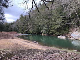
I did hike off the trail and down along Sandy Creek.  It is actually very sandy indeed.  Here’s a nice swimming hole that probably serves fishers in chilly weather and swimmers in warm weather.  It has a broad, sandy beach and deep, clear water.  I’m sure it’s awfully cold to swim in—even in July—but that’s how it is to swim in the streams up here.  I learned to swim in a rocky creek in Venango County called Panther Springs, and it was COLD!  But there’s a unique pleasure to swimming in cold water.  It’s…euphoric…after the initial shock.


And here’s a map of the rail trail system.  It’s modest but praiseworthy.  I love it when people take pride in their communities and try to make them more livable—like turning their ugly industrial waste places into beautiful trails.  Rockland, where I caught the trailhead, is where my father’s family is all buried.  So strange that life has brought me back here.  


Saturday, February 10, 2024

Devies Mountain, Quebec Run Wild Area, Forbes State Forest

Devies Mountain looms behind the trees like a veiled nun behind the rood screen--except maybe slightly more ominous.  Devies Mountain is no slouch when it comes to height, standing at 2,753 feet.  But it's virtually unvisited; there's just no easy way to get there.  This peak stands in the southwest corner of the Quebec Run Wild Area, which is 7,441 acres of protected land within the Forbes State Forest.  That's to say, this mountain is completely protected from drilling and fracking and timbering.  I've always wondered why there's no trail out to it.  By the way, Magazine Mountain, the highest point in Arkansas, is exactly the same height as Devies Mountain, which is the 34th highest peak in Pennsylvania.
This is the leftward, westerly half of the Wild Area.  The black line at the bottom of the map is the Mason Dixon Line.  Devies Mountain stands in pristine isolation just two miles north of the West Virginia line.  I've been hiking and backpacking Quebec Run for over a decade, but I'd never crossed over into the trackless area west of Skyline Drive.  I've always wanted to venture out there, but it takes a lot of commitment and preparation to go where there are no trails.  Also, without trails, you really need to go when there are no leaves on the trees.  
Here's the clearest view of the mountain that I was able to get.  Its so-called "prominence" is 420 feet, which is respectable...as long as you don't start comparing it to the Adirondacks or the Rockies.  Comparison is the thief of joy, no?
I followed a variety of old forest roads in the direction I needed to go, but mostly I bushwhacked.  My goal was to claim this unknown peak on my peak-bagging site, which I had not updated since the summer of 2023.  These old roads are overgrown and littered with fallen trunks and limbs in varying states of decay.  No vehicle comes here now.  Before you begin the ascent, you first have to descend into the valley of Laurel Run, where it's hard to see the mountain that you're trying to climb.  You can see a mountain from afar, but not when you're standing at its foot.  At the foot of a mountain, all you see is a rise in the terrain.  I just headed uphill, crossing over many leafy old roads that zigzag up the mountainside.  
The views from the top were modest, as I knew they would be.  As with so many of these wooded mountains, there'd be nothing to see at all in the summer.  That's what I like about Central Pennsylvania; the mountains have rocky ridges that offer broad vistas and give the illusion of rising above the treeline.  Here in the southwestern part of the state, broad views are harder to come by.  There's a windmill on the opposite ridge that I used as a guide to navigate my way back the way I'd come.
It would be easy to get lost out here, so it's important to mark your way at crucial junctures.  I found my way back down the mountain by leaving sticks stacked against trees at unnatural angles in those place where it would be easy to lose my way.  Devies Mountain is surely named after the family that owned it long ago, 18th century Scotch Irish settlers, no doubt.  It's a place of sweet solitude, and it feels like an achievement to get there without trails, even on an eerily balmy February day when the upland trees are prematurely budding.  I haven't posted in a while because I've been spending my days off working on my new hunting camp up north (though I don't hunt).  It was good to get back in the forest.